IMAGES TAKEN NEAR TO
Highfield, SIDMOUTH, EX10 8XA
Introduction
This page details the photographs taken nearby to Highfield, EX10 8XA by members of the Geograph project.
The Geograph project started in 2005 with the aim of publishing, organising and preserving representative images for every square kilometre of Great Britain, Ireland and the Isle of Man.

There are currently over 7.5m images from over14,400 individuals and you can help contribute to the project by visiting https://www.geograph.org.uk
Image Map
Images are licensed for reuse under creativecommons.org/licenses/by-sa/2.0
Notes
- Clicking on the map will re-center to the selected point.
- The higher the marker number, the further away the image location is from the centre of the postcode.
Image Listing (130 Images Found)
Images are licensed for reuse under creativecommons.org/licenses/by-sa/2.0
Image
Details
Distance
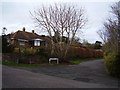
1
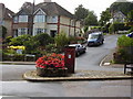
Post Box Peaslands road
This really is in the middle of the road. You can even sit on the bench and wait for the Postman. Situated on the junction of Peasland Road and Brewery lane.
Image: © Anthony Vosper
Taken: 28 Aug 2009
0.03 miles
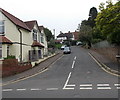
2
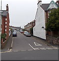
Peaslands Road, Sidmouth
Peaslands Road climbs westwards away from Temple Street.
Image: © Jaggery
Taken: 18 Jun 2013
0.05 miles
3
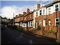
Sidholme Cottages,Brewery Lane
Note the distinct divide in the row of late Victorian houses.
An indication that the row was either built in two stages or by two different builders.
Image: © Anthony Vosper
Taken: 12 Jan 2016
0.11 miles
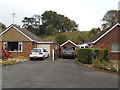
4
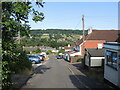
Ascerton Road
A steep one but with a view over the Sid Vale, and located in the Land Part district of Sidmouth.
Image: © Neil Owen
Taken: 16 Jun 2023
0.12 miles
5
Knapp Hill
The tree in the foreground is unusual as it is a'coppiced' Horse Chestnut.
It was cut down as a young tree. The stump then regrew.
Image: © Anthony Vosper
Taken: 27 Jan 2015
0.12 miles
6
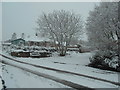
Knapp Hill, snow in March
A coppiced Horse chestnut covered in snow.
Sidmouth rarely has snow. This was the second heavy fall of the year.
Image: © Anthony Vosper
Taken: 18 Mar 2018
0.12 miles
7
A dusting of snow
The orchard on the Knapp. Part of a local nature reserve.
The trees are apple, plumb and pear. The tree that has fallen has been undermined by badgers.
Image: © Anthony Vosper
Taken: 7 Jan 2010
0.13 miles
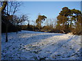
8
Spot the sheep
The Knapp Nature Reserve. Viewed from Knapp Hill.
Sheep are used to graze the hillside over the Winter and Autumn months.
Image: © Anthony Vosper
Taken: 15 Oct 2017
0.13 miles
9
Ascerton Road Sidmouth
Looking west along Ascerton Road from Temple Street.
Image: © Jaggery
Taken: 18 Jun 2013
0.14 miles
