IMAGES TAKEN NEAR TO
The Laurels, SIDMOUTH, EX10 8UX
Introduction
This page details the photographs taken nearby to The Laurels, EX10 8UX by members of the Geograph project.
The Geograph project started in 2005 with the aim of publishing, organising and preserving representative images for every square kilometre of Great Britain, Ireland and the Isle of Man.

There are currently over 7.5m images from over14,400 individuals and you can help contribute to the project by visiting https://www.geograph.org.uk
Image Map
Images are licensed for reuse under creativecommons.org/licenses/by-sa/2.0
Notes
- Clicking on the map will re-center to the selected point.
- The higher the marker number, the further away the image location is from the centre of the postcode.
Image Listing (125 Images Found)
Images are licensed for reuse under creativecommons.org/licenses/by-sa/2.0
Image
Details
Distance
1
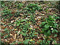
Spring in December
Station Road.
Celandines and Primroses make an early / late appearance.
Image: © Anthony Vosper
Taken: 6 Dec 2015
0.11 miles
2
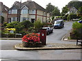
Post Box Peaslands road
This really is in the middle of the road. You can even sit on the bench and wait for the Postman. Situated on the junction of Peasland Road and Brewery lane.
Image: © Anthony Vosper
Taken: 28 Aug 2009
0.12 miles
3
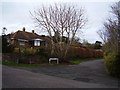
Knapp Hill
The tree in the foreground is unusual as it is a'coppiced' Horse Chestnut.
It was cut down as a young tree. The stump then regrew.
Image: © Anthony Vosper
Taken: 27 Jan 2015
0.12 miles
4
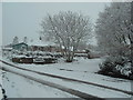
Knapp Hill, snow in March
A coppiced Horse chestnut covered in snow.
Sidmouth rarely has snow. This was the second heavy fall of the year.
Image: © Anthony Vosper
Taken: 18 Mar 2018
0.12 miles
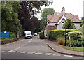
5

Path alongside Station Road, Sidmouth
With a park between the road and the council offices on the left.
Image: © Derek Harper
Taken: 11 Jan 2012
0.12 miles
6
Restored Gas lamp at the Knowle
Sadly now electric, was restored by the Sid Vale ass'n. The lamp is situated on the driveway to the local council office.
Also in the picture is a sign post which caused a local controversy by having the distance in kilometres rather than miles.
Image: © Anthony Vosper
Taken: 28 Aug 2009
0.12 miles
7

Gates to the Knowle
Part of the original gates to Knowle House.
Currently home to The East Devon District Council.
Sidmouth Folk Festival took place in the grounds through these gates.
An OS Bench Mark is located on the reverse of the left hand gate post.
Image: © Anthony Vosper
Taken: 5 Feb 2014
0.13 miles
8
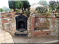
Old drinking fountain and water trough, Sidmouth
Relics of a bygone age, on the corner of Station Road and Peaslands Road.
Image: © Jaggery
Taken: 18 Jun 2013
0.14 miles
9
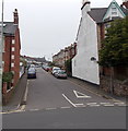
Peaslands Road, Sidmouth
Peaslands Road climbs westwards away from Temple Street.
Image: © Jaggery
Taken: 18 Jun 2013
0.14 miles
10
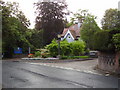
Entrance to council offices, Knowle, Sidmouth
Viewed across Station Road. The blue name board on the left shows
EAST DEVON DISTRICT COUNCIL
Council Offices Knowle.
Image: © Jaggery
Taken: 18 Jun 2013
0.15 miles