IMAGES TAKEN NEAR TO
The Rowans, Woodbine Close, WALTHAM ABBEY, EN9 3RH
Introduction
This page details the photographs taken nearby to The Rowans, Woodbine Close, EN9 3RH by members of the Geograph project.
The Geograph project started in 2005 with the aim of publishing, organising and preserving representative images for every square kilometre of Great Britain, Ireland and the Isle of Man.

There are currently over 7.5m images from over14,400 individuals and you can help contribute to the project by visiting https://www.geograph.org.uk
Image Map
Images are licensed for reuse under creativecommons.org/licenses/by-sa/2.0
Notes
- Clicking on the map will re-center to the selected point.
- The higher the marker number, the further away the image location is from the centre of the postcode.
Image Listing (32 Images Found)
Images are licensed for reuse under creativecommons.org/licenses/by-sa/2.0
Image
Details
Distance

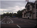
2
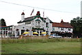
The Woodbine
Public house on Honey Lane.
Image: © Trevor Harris
Taken: 8 Aug 2013
0.08 miles
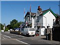
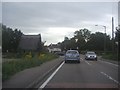
4
The Woodbine
On the A121, across the road from one of the Epping Forest car parks.
Image: © Robin Webster
Taken: 17 Nov 2012
0.09 miles
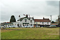
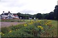
5
Pub behind the plants
Another view of the Woodbine pub, with a few weeds thrown in for effect.
The current landlord is a bit of a refreshment enthusiast and keeps an impressive range of ales and ciders.
Image: © Des Blenkinsopp
Taken: 12 Jun 2014
0.09 miles
7
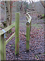
Only thin people please in Epping Forest (Honey Lane Quarters)
This very narrow gap is to prevent horse riders and cyclists churning up the footpath.
As I discovered on the way back to the car park the gap here is not so easy for the larger gentleman to navigate.
Image: © Roger Jones
Taken: 25 Jan 2020
0.10 miles
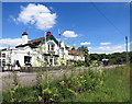
8
Woodridden Hill, Waltham Abbey
Epping Forest and the Volunteer pub are on the left.
Image: © David Howard
Taken: 10 Aug 2011
0.11 miles
9
Honey Lane Plain
An almost empty car park this early on a Sunday morning.
Image: © Glyn Baker
Taken: 23 Jul 2017
0.11 miles
10
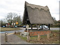
Epping Forest: Honey Lane shelter
All the old Ordnance Survey maps available on line, from 1872 onwards, describe a "Rest House and Water Tank" in this location, on the south side of Honey Lane between the Woodbine and Volunteer public houses. The thatched shelter and its drinking trough are locally listed by Epping Forest District Council as being of architectural or historical merit.
Robert photographed this from a different angle in Image
Image: © Nigel Cox
Taken: 3 Mar 2010
0.13 miles