IMAGES TAKEN NEAR TO
Springfield Road, WALTHAM CROSS, EN8 8TD
Introduction
This page details the photographs taken nearby to Springfield Road, EN8 8TD by members of the Geograph project.
The Geograph project started in 2005 with the aim of publishing, organising and preserving representative images for every square kilometre of Great Britain, Ireland and the Isle of Man.

There are currently over 7.5m images from over14,400 individuals and you can help contribute to the project by visiting https://www.geograph.org.uk
Image Map
Images are licensed for reuse under creativecommons.org/licenses/by-sa/2.0
Notes
- Clicking on the map will re-center to the selected point.
- The higher the marker number, the further away the image location is from the centre of the postcode.
Image Listing (34 Images Found)
Images are licensed for reuse under creativecommons.org/licenses/by-sa/2.0
Image
Details
Distance
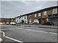
4
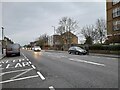
Theobald's Lane at the junction of Crossbrook Street
Image: © David Howard
Taken: 20 Sep 2022
0.11 miles
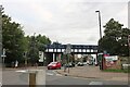
6
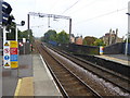
View north from Theobalds Grove station
The line from Edmonton via Lower Edmonton to the centre of Enfield opened on 1st March 1849. The line from Bury Street Junction, north of Edmonton Green, to Cheshunt was opened by the Great Eastern Railway on 1st October 1891 and this is the line seen here at Theobalds Grove station. When it was opened the line was known as the Churchbury Loop. The district was still predominantly rural, and the coming of the tram to Waltham Cross in 1904 saw the railway unable to compete. Passenger services ceased on 1st October 1909, but were reinstated for munitions workers between 1st March 1915 and 1st July 1919.
After that the line was used only by goods trains until electrified as part of a wider scheme at the start of the 1960s. The line is now known as the Southbury Loop. On 31st May 2015 all services here became part of the London Overground network.
Theobalds Grove station was opened at the same time as the rest of the line on 1st October 1891, and closed in 1909, re-opened in 1915, closed again in 1919 and was finally re-opened again in 1960. The goods depot at the station closed in 1967. Its site is now the station car park. The current station building was built in the early 1980s along with several other stations on the line.
Image: © Marathon
Taken: 27 Sep 2017
0.14 miles
7
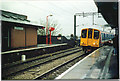
Theobald's Grove Station
Is there anything more dismal than a deserted, suburban railway station, late on a wet afternoon?
Image: © Ron Hann
Taken: Unknown
0.14 miles
8

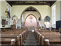
Christ Church, Waltham Cross - Stained glass window
Image: © John Salmon
Taken: 6 Jun 2018
0.14 miles
9
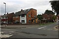
Theobald's Lane at the junction of Dudley Avenue
Image: © David Howard
Taken: 20 Sep 2022
0.14 miles
10
Christ Church, Waltham Cross - East end
Image: © John Salmon
Taken: 6 Jun 2018
0.15 miles