IMAGES TAKEN NEAR TO
Vineyards Road, POTTERS BAR, EN6 4PE
Introduction
This page details the photographs taken nearby to Vineyards Road, EN6 4PE by members of the Geograph project.
The Geograph project started in 2005 with the aim of publishing, organising and preserving representative images for every square kilometre of Great Britain, Ireland and the Isle of Man.

There are currently over 7.5m images from over14,400 individuals and you can help contribute to the project by visiting https://www.geograph.org.uk
Image Map
Images are licensed for reuse under creativecommons.org/licenses/by-sa/2.0
Notes
- Clicking on the map will re-center to the selected point.
- The higher the marker number, the further away the image location is from the centre of the postcode.
Image Listing (9 Images Found)
Images are licensed for reuse under creativecommons.org/licenses/by-sa/2.0
Image
Details
Distance
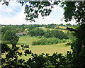
2
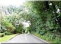
Looking north from the Hertfordshire Way
Looking towards Thornton's Farm
Image: © Robert Eva
Taken: 13 Jun 2017
0.13 miles
3
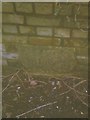
Old Milestone on Vineyard Bridge, Vineyards Road, Northaw
Carved stone plaque by the UC road, in parish of NORTHAW AND CUFFLEY (WELWYN HATFIELD District), Vineyards Road, Northaw, on Vineyard Bridge over Hempshill Brook, in (modern) brickwork of bridge, at ground level, on East side of road. Erected by an unknown authority in the 18th century.
Opposite Milestone: HE_HELN08W Image
Inscription reads:-
17
Miles To
LONDON
Hertfordshire HER & St Albans UAD.
HHER Number: 11625 https://www.heritagegateway.org.uk/Gateway/Results_Single.aspx?uid=MHT11625&resourceID=1008
Milestone Society National ID: HE_HELN08E.
Image: © C Woodward
Taken: 15 Mar 2013
0.14 miles
4
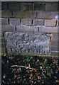
Old Milestone on Vineyard Bridge, Vineyards Road, Northaw
Carved stone plaque by the UC road, in parish of NORTHAW AND CUFFLEY (WELWYN HATFIELD District), Vineyards Road, Northaw, on Vineyard Bridge over Hempshill Brook, in (modern) brickwork of bridge, at ground level, on West side of road. Erected by an unknown authority in the 18th century.
Opposite Milestone: HE_HELN08E Image
Inscription reads:-
8
M(ile)s To
HARTFORD
Hertfordshire HER & St Albans UAD.
HHER Number: 11626 https://www.heritagegateway.org.uk/Gateway/Results_Single.aspx?uid=MHT11626&resourceID=1008
Milestone Society National ID: HE_HELN08W.
Image: © C Woodward
Taken: 15 Mar 2013
0.14 miles
5
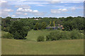
View from the Hertfordshire Way
Looking north from the path towards Thornton's Farm, over a small tributary valley of the Northaw Brook.
Image: © Des Blenkinsopp
Taken: 16 Jun 2016
0.16 miles
6
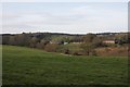
View from the Hertfordshire Way
The field boundary is Hemps Hill Brook, beyond which can be seen buildings on Vineyards Road with Nyn Park in the distance.
Image: © Peter Walker
Taken: 26 Dec 2007
0.20 miles
8
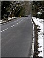
Steep hill into valley north of Northaw village
Approximately 1 in 10 for 250 metres. Popular with cyclists.
Image: © Bikeboy
Taken: 26 Mar 2013
0.22 miles
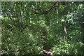
9
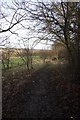
The Hertfordshire Way
Footpath between Northaw and Cuffley, running alongside field boundary to the right and modern tree planting to the left.
Image: © Peter Walker
Taken: 26 Dec 2007
0.24 miles