IMAGES TAKEN NEAR TO
Blanche Lane, POTTERS BAR, EN6 3LD
Introduction
This page details the photographs taken nearby to Blanche Lane, EN6 3LD by members of the Geograph project.
The Geograph project started in 2005 with the aim of publishing, organising and preserving representative images for every square kilometre of Great Britain, Ireland and the Isle of Man.

There are currently over 7.5m images from over14,400 individuals and you can help contribute to the project by visiting https://www.geograph.org.uk
Image Map
Images are licensed for reuse under creativecommons.org/licenses/by-sa/2.0
Notes
- Clicking on the map will re-center to the selected point.
- The higher the marker number, the further away the image location is from the centre of the postcode.
Image Listing (24 Images Found)
Images are licensed for reuse under creativecommons.org/licenses/by-sa/2.0
Image
Details
Distance
1
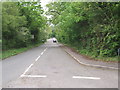
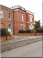
Blanche Lane
Blanche Lane used to go to Barnet. It has been a dead-end since the Barnet By-pass (A1) was constructed. Blanche lane is a hot spot of biological research. Cancer Research UK and NIBS (National Institute for Biological Standards) have labs next door to each other down this lane.
Image: © Bikeboy
Taken: 20 May 2012
0.03 miles
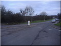
3
Car park on Crossoaks Lane, Ridge
Until recently it was only for buses but the sign prohibiting other vehicles has been taken down and had two cars in it at the time.
Image: © David Howard
Taken: 11 Mar 2021
0.06 miles
5
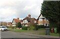
Clare Hall Manor, Ridge
Part of the London Research Institute of Cancer Research UK. Clare Hall manor was renovated in 1998 to provide a restaurant, meeting rooms and accommodation.
Image: © David Hawgood
Taken: 12 Mar 2006
0.09 miles
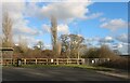
7
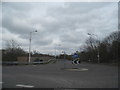
Roundabout at the junction of Earls Lane and Blanche Lane
Image: © David Howard
Taken: 20 Mar 2014
0.16 miles
10
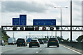
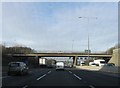
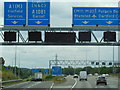
London Orbital Motorway at Bignell's Corner (South Mimms Interchange)
Bignell's Corner (also known as South Mimms Interchange) is a large three-level roundabout interchange providing full access between the M25, A1(M), A1081, South Mimms services and local roads. It is junction 1 of the A1(M) and junction 23 of the M25 (https://www.sabre-roads.org.uk/wiki/index.php?title=Bignells_Corner SABRE).
Image: © David Dixon
Taken: 11 Aug 2023
0.17 miles