IMAGES TAKEN NEAR TO
Cambridge Drive, POTTERS BAR, EN6 3ET
Introduction
This page details the photographs taken nearby to Cambridge Drive, EN6 3ET by members of the Geograph project.
The Geograph project started in 2005 with the aim of publishing, organising and preserving representative images for every square kilometre of Great Britain, Ireland and the Isle of Man.

There are currently over 7.5m images from over14,400 individuals and you can help contribute to the project by visiting https://www.geograph.org.uk
Image Map
Images are licensed for reuse under creativecommons.org/licenses/by-sa/2.0
Notes
- Clicking on the map will re-center to the selected point.
- The higher the marker number, the further away the image location is from the centre of the postcode.
Image Listing (73 Images Found)
Images are licensed for reuse under creativecommons.org/licenses/by-sa/2.0
Image
Details
Distance
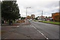
1
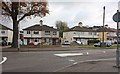
B556 Mutton Lane, Potters Bar
Near the junction with Cranbourne Road
Looking towards the Leisure Centre
Image: © Geographer
Taken: 25 Jul 2009
0.06 miles
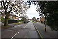
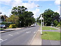
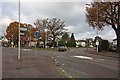
3
Cranbourne Road looking towards Mutton Lane
Image: © David Howard
Taken: 5 Jun 2014
0.07 miles
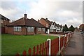
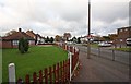
4
Mutton Lane & Cranborne Road, Potters Bar
Image: © John Salmon
Taken: 11 Nov 2008
0.08 miles
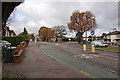
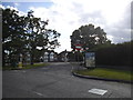
5
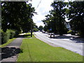
B556 Mutton Lane, Potters Bar
Taken from near the Leisure Centre looking towards Cranbourne Road
Image: © Geographer
Taken: 25 Jul 2009
0.08 miles