IMAGES TAKEN NEAR TO
Mutton Lane, POTTERS BAR, EN6 3BH
Introduction
This page details the photographs taken nearby to Mutton Lane, EN6 3BH by members of the Geograph project.
The Geograph project started in 2005 with the aim of publishing, organising and preserving representative images for every square kilometre of Great Britain, Ireland and the Isle of Man.

There are currently over 7.5m images from over14,400 individuals and you can help contribute to the project by visiting https://www.geograph.org.uk
Image Map
Images are licensed for reuse under creativecommons.org/licenses/by-sa/2.0
Notes
- Clicking on the map will re-center to the selected point.
- The higher the marker number, the further away the image location is from the centre of the postcode.
Image Listing (3 Images Found)
Images are licensed for reuse under creativecommons.org/licenses/by-sa/2.0
Image
Details
Distance

2
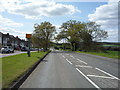
Speed cameras on Mutton Lane (B556), Potters Bar
Looking west.
Image: © JThomas
Taken: 15 Apr 2017
0.21 miles
3
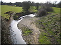
Mimmshall Brook near Potters Bar
Viewed looking upstream and southwards from the Warrengate Lane bridge, Mimmshall Brook is a tributary of the River Colne, and although the water is flowing northwards here, it will eventually turn southwards to drain into the River Thames.
Image: © Nigel Cox
Taken: 22 Mar 2006
0.25 miles