IMAGES TAKEN NEAR TO
Dugdale Hill Lane, POTTERS BAR, EN6 2DU
Introduction
This page details the photographs taken nearby to Dugdale Hill Lane, EN6 2DU by members of the Geograph project.
The Geograph project started in 2005 with the aim of publishing, organising and preserving representative images for every square kilometre of Great Britain, Ireland and the Isle of Man.

There are currently over 7.5m images from over14,400 individuals and you can help contribute to the project by visiting https://www.geograph.org.uk
Image Map
Images are licensed for reuse under creativecommons.org/licenses/by-sa/2.0
Notes
- Clicking on the map will re-center to the selected point.
- The higher the marker number, the further away the image location is from the centre of the postcode.
Image Listing (14 Images Found)
Images are licensed for reuse under creativecommons.org/licenses/by-sa/2.0
Image
Details
Distance
1
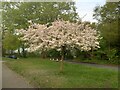
Tree in blossom, Dugdale Hill Lane, Potters Bar
Image: © Bikeboy
Taken: 20 Apr 2022
0.06 miles
2
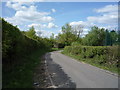
Sawyers Lane
Looking north west the wrong way up a one way road.
Image: © JThomas
Taken: 15 Apr 2017
0.17 miles
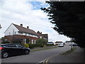
5
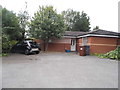
Bungalow on Stevens Close, Potters Bar
Image: © David Howard
Taken: 29 Jul 2015
0.20 miles
6
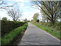
Sawyers Lane
Looking north west the wrong way up a one way road.
Image: © JThomas
Taken: 15 Apr 2017
0.22 miles
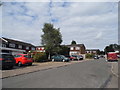
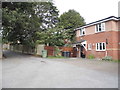
9
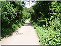
Bridgefoot Lane
Much beloved by smoking pupils form the neighbouring school. It is a dead end for cars, but leads onto a footpath.
Image: © Bikeboy
Taken: 30 Jun 2012
0.23 miles
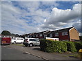
10
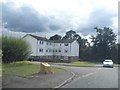
Flats on Kimptons Mead, Potters Bar
On the very edge of town
Image: © David Howard
Taken: 29 Jul 2015
0.23 miles