IMAGES TAKEN NEAR TO
Pinewood Drive, POTTERS BAR, EN6 2BD
Introduction
This page details the photographs taken nearby to Pinewood Drive, EN6 2BD by members of the Geograph project.
The Geograph project started in 2005 with the aim of publishing, organising and preserving representative images for every square kilometre of Great Britain, Ireland and the Isle of Man.

There are currently over 7.5m images from over14,400 individuals and you can help contribute to the project by visiting https://www.geograph.org.uk
Image Map
Images are licensed for reuse under creativecommons.org/licenses/by-sa/2.0
Notes
- Clicking on the map will re-center to the selected point.
- The higher the marker number, the further away the image location is from the centre of the postcode.
Image Listing (45 Images Found)
Images are licensed for reuse under creativecommons.org/licenses/by-sa/2.0
Image
Details
Distance
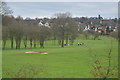
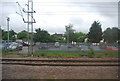
2
Car park near Potters Bar railway station
From an East Coast train heading North.
Image: © Steve Fareham
Taken: 29 Jun 2010
0.14 miles
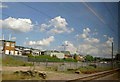
6
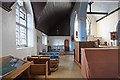
King Charles the Martyr Church, Mutton Lane, Potters Bar - North Chapel
Image: © John Salmon
Taken: 11 Nov 2008
0.21 miles
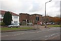
7
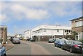
Station Close, Potters Bar
A small trading estate near Potters Bar station.
Image: © Des Blenkinsopp
Taken: 16 Jun 2016
0.21 miles
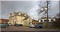
8
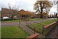
Furzefield Court, Mutton Lane, Potters Bar
Image: © John Salmon
Taken: 11 Nov 2008
0.21 miles
10
Cranborne Centre, Mutton Lane, Potters Bar
Image: © John Salmon
Taken: 11 Nov 2008
0.22 miles