IMAGES TAKEN NEAR TO
Inglefield, POTTERS BAR, EN6 1HD
Introduction
This page details the photographs taken nearby to Inglefield, EN6 1HD by members of the Geograph project.
The Geograph project started in 2005 with the aim of publishing, organising and preserving representative images for every square kilometre of Great Britain, Ireland and the Isle of Man.

There are currently over 7.5m images from over14,400 individuals and you can help contribute to the project by visiting https://www.geograph.org.uk
Image Map
Images are licensed for reuse under creativecommons.org/licenses/by-sa/2.0
Notes
- Clicking on the map will re-center to the selected point.
- The higher the marker number, the further away the image location is from the centre of the postcode.
Image Listing (9 Images Found)
Images are licensed for reuse under creativecommons.org/licenses/by-sa/2.0
Image
Details
Distance
1
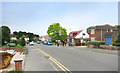
Darkes Lane
A car, climbing out of central Potters Bar, rounds the corner of Darkes Lane onto Church Road. The view is taken from the junction with Heath Road.
Image: © Martin Addison
Taken: 16 Apr 2006
0.06 miles
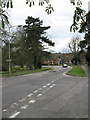
2
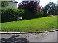
Mountway at Church Road
The signpost is for the Hertfordshire Way which goes down Mountway
Image: © Robert Eva
Taken: 13 Jun 2017
0.08 miles
4
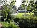
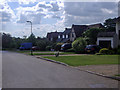
Golf Club at Potters Bar
A stream flows in the dark patch of the photo foreground
Image: © Jack Hill
Taken: 2 Aug 2005
0.14 miles
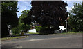
7
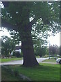
Tree on corner of Manor Way, Potters Bar
Image: © David Howard
Taken: 21 May 2009
0.23 miles
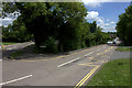
8
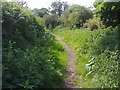
Hertfordshire Way
The footpath crossing Potters Bar from south to north as it leaves Manor Way
Image: © David Howard
Taken: 21 May 2009
0.23 miles