IMAGES TAKEN NEAR TO
Church Road, POTTERS BAR, EN6 1EZ
Introduction
This page details the photographs taken nearby to Church Road, EN6 1EZ by members of the Geograph project.
The Geograph project started in 2005 with the aim of publishing, organising and preserving representative images for every square kilometre of Great Britain, Ireland and the Isle of Man.

There are currently over 7.5m images from over14,400 individuals and you can help contribute to the project by visiting https://www.geograph.org.uk
Image Map
Images are licensed for reuse under creativecommons.org/licenses/by-sa/2.0
Notes
- Clicking on the map will re-center to the selected point.
- The higher the marker number, the further away the image location is from the centre of the postcode.
Image Listing (18 Images Found)
Images are licensed for reuse under creativecommons.org/licenses/by-sa/2.0
Image
Details
Distance
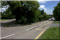
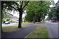
2
Darkes Lane
A car, climbing out of central Potters Bar, rounds the corner of Darkes Lane onto Church Road. The view is taken from the junction with Heath Road.
Image: © Martin Addison
Taken: 16 Apr 2006
0.14 miles
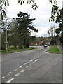
3
Mountway at Church Road
The signpost is for the Hertfordshire Way which goes down Mountway
Image: © Robert Eva
Taken: 13 Jun 2017
0.14 miles
4
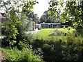
Golf Club at Potters Bar
A stream flows in the dark patch of the photo foreground
Image: © Jack Hill
Taken: 2 Aug 2005
0.15 miles
5
Church Road, Potters Bar, Hertfordshire
Looking west along Church Road, Potters Bar, Hertfordshire towards, Darkes Lane.
Image: © David Dewar
Taken: 21 Sep 2007
0.21 miles
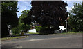
6
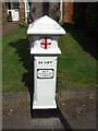
Coal Tax Pillar
This, I believe (from looking at other Geographs) is a Coal Tax Pillar, marking the boundary of the London Coal Tax area where a levy had to be paid if coal passed this point. Cf. Image]
24 VICT probably indicates that it was erected in the 24th year of Queen Victoria's reign, i.e. 1861
Image: © Rob Farrow
Taken: 18 Apr 2006
0.22 miles
7
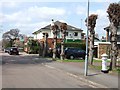
The Builder's Arms, Potters Bar
The Builder's Arms in Heath Road, Little Heath, Potters Bar.
On the right can be seen what I believe (from looking at other Geographs) is a Image], marking the boundary of the London Coal Tax area where a levy had to be paid if coal passed this point.
Image: © Rob Farrow
Taken: 18 Apr 2006
0.22 miles
8
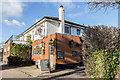
The Builders' Arms, Heath Road, Potters Bar, Hertfordshire
This McMullen public houses is hidden in a residential area.
Image: © Christine Matthews
Taken: 9 Jan 2014
0.22 miles
9
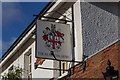
In Sign, The Builder's Arms, Heath Road, Potters Bar, Hertfordshire
This public house is situated in a quiet residential area near a school.
Image: © Christine Matthews
Taken: 9 Jan 2014
0.22 miles
10
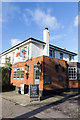
The Builder's Arms, Heath Road, Potters Bar, Hertfordshire
This public house is situated in a quiet residential area near a school.
Image: © Christine Matthews
Taken: 9 Jan 2014
0.22 miles