IMAGES TAKEN NEAR TO
Hadley Road, BARNET, EN5 5QS
Introduction
This page details the photographs taken nearby to Hadley Road, EN5 5QS by members of the Geograph project.
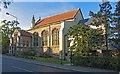
The Geograph project started in 2005 with the aim of publishing, organising and preserving representative images for every square kilometre of Great Britain, Ireland and the Isle of Man.

There are currently over 7.5m images from over14,400 individuals and you can help contribute to the project by visiting https://www.geograph.org.uk
Image Map
Images are licensed for reuse under creativecommons.org/licenses/by-sa/2.0
Notes
- Clicking on the map will re-center to the selected point.
- The higher the marker number, the further away the image location is from the centre of the postcode.
Image Listing (35 Images Found)
Images are licensed for reuse under creativecommons.org/licenses/by-sa/2.0
Image
Details
Distance
1
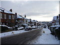
Hadley Road, Barnet
Looking down Hadley Road towards Barnet from the junction with Tudor Road.
Image: © Christine Matthews
Taken: 7 Jan 2010
0.07 miles
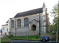
2
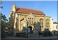
St Mark, Potter's Road, Barnet Vale, Herts
Image: © John Salmon
Taken: 4 Nov 2006
0.09 miles
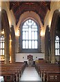
3
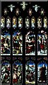
St Mark, Potter's Road, Barnet Vale, Herts - Window
Image: © John Salmon
Taken: 8 Nov 2006
0.09 miles
4
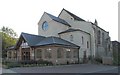
St Mark, Potter's Road, Barnet Vale, Herts
Including new hall at east end.
Image: © John Salmon
Taken: 4 Nov 2006
0.09 miles
5
St Mark, Potter's Road, Barnet Vale, Herts - West end
Image: © John Salmon
Taken: 8 Nov 2006
0.09 miles
6
St Mark, Potters Road, Barnet Vale, Herts
Image: © John Salmon
Taken: 5 Nov 2006
0.09 miles
7
St Mark, Potter's Road, Barnet Vale, Herts
Image: © John Salmon
Taken: 4 Nov 2006
0.09 miles
8
St Mark, Potter's Road, Barnet Vale, Herts
Image: © John Salmon
Taken: 4 Nov 2006
0.09 miles
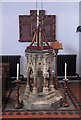
9
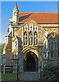
St Mark, Potter's Road, Barnet Vale, Herts - Porch
Image: © John Salmon
Taken: 4 Nov 2006
0.09 miles