IMAGES TAKEN NEAR TO
Bulwer Road, BARNET, EN5 5JD
Introduction
This page details the photographs taken nearby to Bulwer Road, EN5 5JD by members of the Geograph project.
The Geograph project started in 2005 with the aim of publishing, organising and preserving representative images for every square kilometre of Great Britain, Ireland and the Isle of Man.

There are currently over 7.5m images from over14,400 individuals and you can help contribute to the project by visiting https://www.geograph.org.uk
Image Map
Images are licensed for reuse under creativecommons.org/licenses/by-sa/2.0
Notes
- Clicking on the map will re-center to the selected point.
- The higher the marker number, the further away the image location is from the centre of the postcode.
Image Listing (88 Images Found)
Images are licensed for reuse under creativecommons.org/licenses/by-sa/2.0
Image
Details
Distance
1
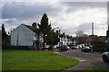
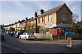
Shaftesbury Avenue
Looking from the green beside Cromer Road.
Image: © Martin Addison
Taken: 21 Nov 2008
0.09 miles
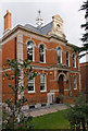
2

Barnet Telephone Exchange (2)
Taken in Leicester Road, New Barnet, this photo shows the TE extension on the right of the photo whilst the original building is to its left. This TE now has 0208-440, 441 and 449 xxxx numbers, plus some Outer London numbers. Mobile phone aerials can be seen on the roof of this latter building.
Image: © David Hillas
Taken: 8 Jun 2013
0.10 miles
3
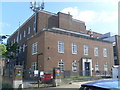
Barnet Telephone Exchange (1)
Located at 5 Leicester Road, New Barnet EN5 5EP, this TE dates from the late 1940s and used to have BARnet and HADley Wood numbers until the late 1960s. Besides Barnet and Hadley Wood, this TE also serves Arkley and Cockfosters nearby. The vehicle entrance with the blue IN signs and 5mph sign can be seen to the left of the photo, whilst mobile phone aerials can be seen of the roof of this large building.
Image: © David Hillas
Taken: 8 Jun 2013
0.10 miles
4
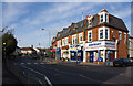
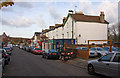
Potters Road
A small parade of shops at the junction with Cromer Road.
Image: © Martin Addison
Taken: 21 Nov 2008
0.10 miles
5
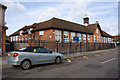
Cromer Road Primary School
The Hertfordshire coat of arms adorns the centre of the facade.
Image: © Martin Addison
Taken: 21 Nov 2008
0.11 miles
6
Bulwer Road
Seen from the junction with Plantagenet Road. The corner shop, number 54a, has clearly not served in that function for many years and the forecourt has become a repository for dead vehicles. The faded paint work above the window suggests that it may once have been a newsagent.
Image: © Martin Addison
Taken: 21 Nov 2008
0.11 miles
7
Lytton Road
Lots of small business premises and take away's along this street backing onto the Kings Cross mainline.
Image: © Martin Addison
Taken: 21 Nov 2008
0.11 miles
8
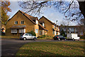
Cromer Road
Housing on the extension of this road into a mini-estate. seen from the junction with Boleyn Way.
Image: © Martin Addison
Taken: 21 Nov 2008
0.13 miles
9
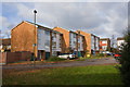
Cromer Road
Some of the housing on this mini-estate next to the Kings Cross mainline.
Image: © Martin Addison
Taken: 21 Nov 2008
0.13 miles
10
32 Station Road, New Barnet
This building currently appears to be housing, but the small statue in the stone work on the roof and the mini-spire hint at a past religious function. The building appears in old post cards complete with a church style notice board beside the gate. Further research required.
Image: © Martin Addison
Taken: 21 Nov 2008
0.14 miles