IMAGES TAKEN NEAR TO
Lee Close, BARNET, EN5 5HP
Introduction
This page details the photographs taken nearby to Lee Close, EN5 5HP by members of the Geograph project.
The Geograph project started in 2005 with the aim of publishing, organising and preserving representative images for every square kilometre of Great Britain, Ireland and the Isle of Man.

There are currently over 7.5m images from over14,400 individuals and you can help contribute to the project by visiting https://www.geograph.org.uk
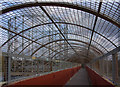
Image Map
Images are licensed for reuse under creativecommons.org/licenses/by-sa/2.0
Notes
- Clicking on the map will re-center to the selected point.
- The higher the marker number, the further away the image location is from the centre of the postcode.
Image Listing (62 Images Found)
Images are licensed for reuse under creativecommons.org/licenses/by-sa/2.0
Image
Details
Distance
1
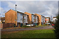
Cromer Road
Some of the housing on this mini-estate next to the Kings Cross mainline.
Image: © Martin Addison
Taken: 21 Nov 2008
0.04 miles
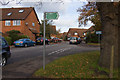
2
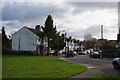
Shaftesbury Avenue
Looking from the green beside Cromer Road.
Image: © Martin Addison
Taken: 21 Nov 2008
0.04 miles
3
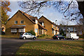
Cromer Road
Housing on the extension of this road into a mini-estate. seen from the junction with Boleyn Way.
Image: © Martin Addison
Taken: 21 Nov 2008
0.05 miles
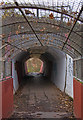
4
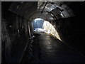
Subway under the East Coast main railway line, New Barnet
This pedestrian subway passes under the main East Coast railway line close to New Barnet station. It connects the Victoria Recreation Ground with Cromer Road.
Image: © Paul Bryan
Taken: 8 Mar 2014
0.06 miles
5
Boleyn Way
Looking into this housing estate on the end of Cromer Road. Cromer Road itself has been extended on the right to form a mini-estate. The sign indicates the footpath to Victoria Recreation Ground.
Image: © Martin Addison
Taken: 21 Nov 2008
0.08 miles
6
Footpath to Cromer Road
Looking through the tunnel under the Mainline from Kings Cross, from the footbridge across the Gas Alliance compound.
Image: © Martin Addison
Taken: 21 Nov 2008
0.08 miles
7
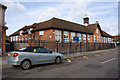
Cromer Road Primary School
The Hertfordshire coat of arms adorns the centre of the facade.
Image: © Martin Addison
Taken: 21 Nov 2008
0.09 miles

9
Footpath to Cromer Road
The footpath crosses over the Gas Alliance depot, which is accessed from Albert Road, on an enclosed footbridge. The metal grill lends a forbidding air to the footpath. It is presumably there to deter vandals from throwing things onto the vehicles and gas pipes below. This view is looking back towards the Victoria Recreation Ground.
Image: © Martin Addison
Taken: 21 Nov 2008
0.13 miles
