IMAGES TAKEN NEAR TO
Dyrham Lane, BARNET, EN5 4RB
Introduction
This page details the photographs taken nearby to Dyrham Lane, EN5 4RB by members of the Geograph project.
The Geograph project started in 2005 with the aim of publishing, organising and preserving representative images for every square kilometre of Great Britain, Ireland and the Isle of Man.

There are currently over 7.5m images from over14,400 individuals and you can help contribute to the project by visiting https://www.geograph.org.uk
Image Map
Images are licensed for reuse under creativecommons.org/licenses/by-sa/2.0
Notes
- Clicking on the map will re-center to the selected point.
- The higher the marker number, the further away the image location is from the centre of the postcode.
Image Listing (12 Images Found)
Images are licensed for reuse under creativecommons.org/licenses/by-sa/2.0
Image
Details
Distance
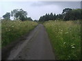
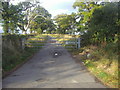
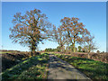
5
Dyrham Lane, Ridge
Approaching the farm
Image: © David Howard
Taken: 20 Jul 2012
0.10 miles
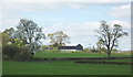
6
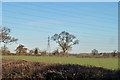
Fields east of Dyrham Lane
Distantly the M25 is visible.
Image: © Robin Webster
Taken: 2 Dec 2012
0.12 miles
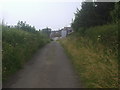
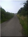
7
Dyrham Lane, Ridge
The lane only provides access to Dyrham Park farm
Image: © David Howard
Taken: 20 Jul 2012
0.12 miles
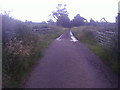
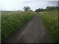
8
Dyrham Lane
Leading to Dyrham Park Farm.
Image: © Robin Webster
Taken: 2 Dec 2012
0.13 miles
9
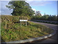
Corner of Dyrham Lane and Trotters Bottom
Image: © David Howard
Taken: 25 Oct 2011
0.23 miles