IMAGES TAKEN NEAR TO
Barnet Gate, BARNET, EN5 3HZ
Introduction
This page details the photographs taken nearby to Barnet Gate, EN5 3HZ by members of the Geograph project.
The Geograph project started in 2005 with the aim of publishing, organising and preserving representative images for every square kilometre of Great Britain, Ireland and the Isle of Man.

There are currently over 7.5m images from over14,400 individuals and you can help contribute to the project by visiting https://www.geograph.org.uk
Image Map
Images are licensed for reuse under creativecommons.org/licenses/by-sa/2.0
Notes
- Clicking on the map will re-center to the selected point.
- The higher the marker number, the further away the image location is from the centre of the postcode.
Image Listing (36 Images Found)
Images are licensed for reuse under creativecommons.org/licenses/by-sa/2.0
Image
Details
Distance
2
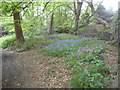
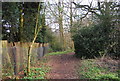
Path to Moat Mount from Hendon Wood Lane
Image: © David Howard
Taken: 30 Apr 2014
0.12 miles
4
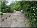
Access road for houses, Hendon Wood Lane
Image: © David Howard
Taken: 9 Jul 2009
0.15 miles
6
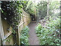
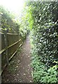
Path to Moat Mount from Hendon Wood Lane
Image: © David Howard
Taken: 30 Apr 2014
0.16 miles
7
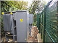
Transformer by Hendon Wood Lane, Mill Hill
Image: © David Howard
Taken: 30 Apr 2014
0.16 miles
8
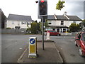
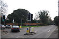
Hendon Wood Lane at the junction of Barnet Road
This is the end of the London postal district, being in NW7. It neither is in or leads to Hendon, and caused me to get extremely lost as a result when I was about 11.
Image: © David Howard
Taken: 30 Apr 2014
0.16 miles
9
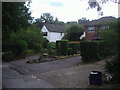
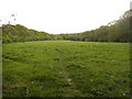
Houses on Hendon Wood Lane
Reachable by access road alongside the main part.
Image: © David Howard
Taken: 9 Jul 2009
0.16 miles