IMAGES TAKEN NEAR TO
Aitken Road, BARNET, EN5 3AD
Introduction
This page details the photographs taken nearby to Aitken Road, EN5 3AD by members of the Geograph project.
The Geograph project started in 2005 with the aim of publishing, organising and preserving representative images for every square kilometre of Great Britain, Ireland and the Isle of Man.

There are currently over 7.5m images from over14,400 individuals and you can help contribute to the project by visiting https://www.geograph.org.uk
Image Map
Images are licensed for reuse under creativecommons.org/licenses/by-sa/2.0
Notes
- Clicking on the map will re-center to the selected point.
- The higher the marker number, the further away the image location is from the centre of the postcode.
Image Listing (22 Images Found)
Images are licensed for reuse under creativecommons.org/licenses/by-sa/2.0
Image
Details
Distance
1
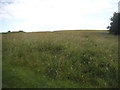
View from Whitings Hill open space, Barnet
Image: © David Howard
Taken: 1 Jul 2014
0.07 miles
2
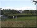
View from Whitings Hill open space, Barnet
Image: © David Howard
Taken: 1 Jul 2014
0.08 miles
3
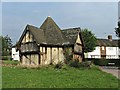
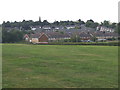
Barnet Physic Well, Well Road, Chipping Barnet
Barnet Physic Well, Well Road, Chipping Barnet. Used to be a source of mineral water.
Image: © Christine Matthews
Taken: 22 Sep 2005
0.11 miles
4

Arkley: Garthland Drive
This road is locally about the last suburban one in the built-up area of Greater London.
Image: © Nigel Cox
Taken: 7 Mar 2015
0.12 miles
6
Ryecroft Crescent, Barnet
Off Quinta Drive.
Image: © JThomas
Taken: 15 Apr 2017
0.15 miles
9
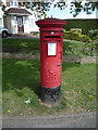
Elizabeth II postbox on Quinta Drive, Arkley, Barnet
Postbox No. EN5 281.
See Image] for context.
Image: © JThomas
Taken: 15 Apr 2017
0.17 miles