IMAGES TAKEN NEAR TO
Dollis Valley Way, BARNET, EN5 2UL
Introduction
This page details the photographs taken nearby to Dollis Valley Way, EN5 2UL by members of the Geograph project.
The Geograph project started in 2005 with the aim of publishing, organising and preserving representative images for every square kilometre of Great Britain, Ireland and the Isle of Man.

There are currently over 7.5m images from over14,400 individuals and you can help contribute to the project by visiting https://www.geograph.org.uk
Image Map
Images are licensed for reuse under creativecommons.org/licenses/by-sa/2.0
Notes
- Clicking on the map will re-center to the selected point.
- The higher the marker number, the further away the image location is from the centre of the postcode.
Image Listing (42 Images Found)
Images are licensed for reuse under creativecommons.org/licenses/by-sa/2.0
Image
Details
Distance
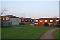
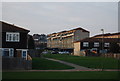
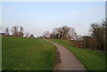
2
More Houses
New housing development underway on what were, I believe, allotments. View taken from the Dollis Valley Green Walk looking towards Dollis Valley Way housing estate.
Image: © Martin Addison
Taken: 1 Apr 2007
0.06 miles
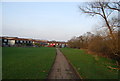
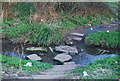
10
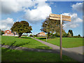
Loop & Greenwalk
The London Loop LDP and Dollis Valley Greenwalk share route and signage along this section.
Image: © Des Blenkinsopp
Taken: 24 Oct 2013
0.15 miles