IMAGES TAKEN NEAR TO
Alan Drive, BARNET, EN5 2PP
Introduction
This page details the photographs taken nearby to Alan Drive, EN5 2PP by members of the Geograph project.
The Geograph project started in 2005 with the aim of publishing, organising and preserving representative images for every square kilometre of Great Britain, Ireland and the Isle of Man.

There are currently over 7.5m images from over14,400 individuals and you can help contribute to the project by visiting https://www.geograph.org.uk
Image Map
Images are licensed for reuse under creativecommons.org/licenses/by-sa/2.0
Notes
- Clicking on the map will re-center to the selected point.
- The higher the marker number, the further away the image location is from the centre of the postcode.
Image Listing (34 Images Found)
Images are licensed for reuse under creativecommons.org/licenses/by-sa/2.0
Image
Details
Distance

4
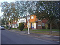
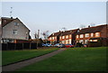
Mayhill Road
Houses at the southern end of Mayhill Road viewed from the fields beside Dollis Brook.
Image: © Martin Addison
Taken: 1 Apr 2007
0.08 miles

10
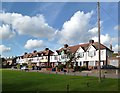
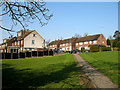
Dollis Brook Walk
A distinctive terrace overlooking a small park beside the Dollis Brook.
On the London Loop LDP.
Image: © Des Blenkinsopp
Taken: 24 Oct 2013
0.09 miles