IMAGES TAKEN NEAR TO
Fitzjohn Avenue, BARNET, EN5 2HW
Introduction
This page details the photographs taken nearby to Fitzjohn Avenue, EN5 2HW by members of the Geograph project.
The Geograph project started in 2005 with the aim of publishing, organising and preserving representative images for every square kilometre of Great Britain, Ireland and the Isle of Man.

There are currently over 7.5m images from over14,400 individuals and you can help contribute to the project by visiting https://www.geograph.org.uk
Image Map
Images are licensed for reuse under creativecommons.org/licenses/by-sa/2.0
Notes
- Clicking on the map will re-center to the selected point.
- The higher the marker number, the further away the image location is from the centre of the postcode.
Image Listing (162 Images Found)
Images are licensed for reuse under creativecommons.org/licenses/by-sa/2.0
Image
Details
Distance
2
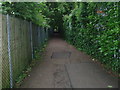
Path between Fitzjohn Av and Manor Road
This path links Mays Lane with Wood Street going through the Old Court Recreation Ground. The gardens of Fitzjohn Av. back onto the east (right) side and those of Manor Rd back onto the west side. It is always quite overgrown and gloomy. A stream appears during wet weather, crossing the path and disappearing into the gardens of Fitzjohn Av. The stream is visible on old maps made before the houses were built early in the 20th century.
Image: © Bikeboy
Taken: 14 Jun 2012
0.06 miles
3
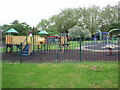
Children's playground in the Old Court Recreation Ground
The big yellow castle thing on the left is the oldest structure here-it is at least 15 years old. All the other stuff is quite new. Until about 10 years ago there was a large old tree in the middle (to the right of the yellow castle). It was chopped down, the stump was pulped and the hole filled in and covered in the soft spongy stuff they use for covering playgrounds-not like when I was a kid-knocking my head on concrete never did me any harm!
Image: © Bikeboy
Taken: 14 Jun 2012
0.09 miles
4
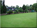
Bowling green and pavilion in Old Court House Recreation Ground
Confirming preconceptions and stereotypes, I'm afraid all the people you see bowling here are elderly.
Image: © Bikeboy
Taken: 14 Jun 2012
0.09 miles
5
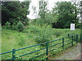
Tennis Court Conservation Area at the back of Fitzjohn Avenue
See http://www.geograph.org.uk/photo/2992765 for a picture of the other tennis courts. This was the last one of the series and was very overgrown with weeds growing through the tarmac etc. When Barnet Council renovated the other courts they decided to leave this one as it was. It is an interesting experiment in how plants reclaim developed areas as well as providing a habitat for plants and insects etc in a built up area.
Image: © Bikeboy
Taken: 14 Jun 2012
0.10 miles
6
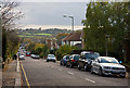
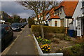
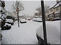
Manor Road
Looking down the hill into the valley carved by Dollis Brook. The green fields in the distance lend this aspect of Barnet an almost rural air - arable and dairy farming are still carried out on the south side of the brook between Barnet and Totteridge.
Below, a 184 bus begins the long grind up the hill to Wood Street. The clouds that have given a grey Remembrance Day are breaking up and it's going to be a sunny late autumn afternoon.
Image: © Martin Addison
Taken: 8 Nov 2009
0.10 miles
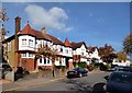
7
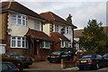
Inter-war houses, Manor Road, Barnet
The concrete sunburst on the left-hand house is a very typical 1930s motif.
Image: © Christopher Hilton
Taken: 21 Mar 2016
0.11 miles
8
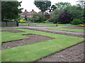
Old Court Recreation Ground
A bad time to take this photo as they have just cleared the spring flower beds before replanting them in summer. The houses in the background are those of Orchard Avenue (c1900). There was an orchard here prior to the building of the houses.
Image: © Bikeboy
Taken: 14 Jun 2012
0.12 miles
9
Houses in Bedford Avenue
Suburban architecture doesn't have to be bland.
Image: © Des Blenkinsopp
Taken: 24 Oct 2013
0.13 miles