IMAGES TAKEN NEAR TO
Gloucester Road, BARNET, EN5 1TA
Introduction
This page details the photographs taken nearby to Gloucester Road, EN5 1TA by members of the Geograph project.
The Geograph project started in 2005 with the aim of publishing, organising and preserving representative images for every square kilometre of Great Britain, Ireland and the Isle of Man.

There are currently over 7.5m images from over14,400 individuals and you can help contribute to the project by visiting https://www.geograph.org.uk
Image Map
Images are licensed for reuse under creativecommons.org/licenses/by-sa/2.0
Notes
- Clicking on the map will re-center to the selected point.
- The higher the marker number, the further away the image location is from the centre of the postcode.
Image Listing (26 Images Found)
Images are licensed for reuse under creativecommons.org/licenses/by-sa/2.0
Image
Details
Distance
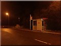
2
Looking down Longmore Avenue, New Barnet
Snow in February 2007
Image: © Ken Amphlett
Taken: 8 Feb 2007
0.12 miles
3
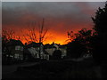
Sky over Longmore Avenue, New Barnet
This photo was taken on the evening of the oil blast in Hemel Hempstead in December 2005.
Image: © Ken Amphlett
Taken: 11 Dec 2005
0.12 miles
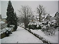
4
Longmore Avenue, New Barnet
For those interested in small London rivers, we are at the top of the divide between Pymme's Brook in the Lea catchment (in front) and Dollis Brook in the Brent catchment.
Image: © Des Blenkinsopp
Taken: 26 Feb 2019
0.13 miles
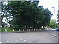
5
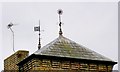
Weather Vanes, New Barnet
These weather vanes are on top of the old victorian house which is the headquarters building of the Society of African Missions in Lyonsdown Rd. It is unknown what the letter H stands for.
Image: © Nigel Mykura
Taken: 22 Dec 2008
0.13 miles
6
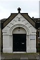
SMA House Lyonsdown , East Barnet
This is the entrance door to the HQ of the Society of African Mission.
Image: © Nigel Mykura
Taken: 22 Dec 2008
0.13 miles
7
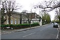
Society of African Missions, Lyonsdown, East Barnet
The large house on the left houses the Society of African Missions. The house is described as SMA House on the door plaque presumably because they did not want to be known as SAM House
Image: © Nigel Mykura
Taken: 22 Dec 2008
0.13 miles
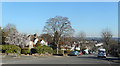
8
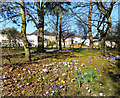
Spring Flowers by Lyonsdown Road
A tiny park on an island between the roads.
Image: © Des Blenkinsopp
Taken: 26 Feb 2019
0.16 miles
10
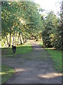
Entrance to Greenhill Park
Greenhill Gardens is a small public park in High Barnet in the London Borough of Barnet. Its main feature is an ornamental lake which attracts many birds, and it also has a grassed area with scattered mature trees. It is a Local Nature Reserve.
The park is the small surviving part of large country estate known as Pricklers, named after a medieval family called Prittle. The estate became Greenhill Gardens in the 16th century, and it was split up when Thomas Henry Wyatt built Willenhall in the southern part. Most of the land was developed for housing in the twentieth century. In July 1926 East Barnet Council purchased the land which is now a public park for £20,000. In 1965 East Barnet became part of the London Borough of Barnet, which now owns and manages the park.
Image: © Christine Westerback
Taken: 17 Sep 2010
0.18 miles