IMAGES TAKEN NEAR TO
Albert Road, BARNET, EN4 9SH
Introduction
This page details the photographs taken nearby to Albert Road, EN4 9SH by members of the Geograph project.
The Geograph project started in 2005 with the aim of publishing, organising and preserving representative images for every square kilometre of Great Britain, Ireland and the Isle of Man.

There are currently over 7.5m images from over14,400 individuals and you can help contribute to the project by visiting https://www.geograph.org.uk
Image Map
Images are licensed for reuse under creativecommons.org/licenses/by-sa/2.0
Notes
- Clicking on the map will re-center to the selected point.
- The higher the marker number, the further away the image location is from the centre of the postcode.
Image Listing (131 Images Found)
Images are licensed for reuse under creativecommons.org/licenses/by-sa/2.0
Image
Details
Distance
1

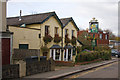
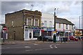
Salvation Army Church, New Barnet
The church, which the datestone reveals was built in 1886, is located on Albert Road, just off East Barnet Road. The rather incongruously positioned signs advertising cask ale actually belong to The Builders Arms public house opposite the church. The gasometer at the Albert Road Gas Works can be seen in the background.
Image: © Paul Bryan
Taken: 8 Mar 2014
0.01 miles
2
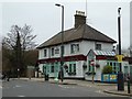
The Builders Arms
A small Greene King pub tucked away down Albert Road directly behind The Railway Bell, a Wetherspoons establishment. I wonder how much trade it gets?
Image: © Martin Addison
Taken: 21 Nov 2008
0.01 miles
3
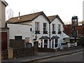
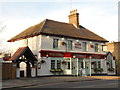
The Builders Arms, New Barnet
This popular real ale pub is located on Albert Road, just off East Barnet Road.
Image: © Paul Bryan
Taken: 8 Mar 2014
0.01 miles
4
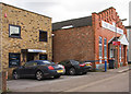
Offices and the Salvation Army
A small office unit and a Salvation Army hall on Albert Road, New Barnet. The hall was built in 1886.
Image: © Martin Addison
Taken: 21 Nov 2008
0.02 miles
5
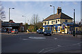
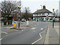
The Railway Bell
A Wetherspoons free house located on the corner of Albert Road and East Barnet Road, which passes under the Kings Cross mainline on the left. The road on the extreme right is Victoria Road, whilst the road on the left by the bridge is Approach Road.
Image: © Martin Addison
Taken: 21 Nov 2008
0.02 miles
6
Shops on Victoria Road
This short terrace of shops is situated between the two junctions of Albert Road with Victoria Road by the junction of the latter with East Barnet Road.
Image: © Martin Addison
Taken: 21 Nov 2008
0.03 miles
7
The Railway Bell
The Railway Bell, a Wetherspoons pub in New Barnet.
Image: © Philip Halling
Taken: 19 Feb 2017
0.03 miles
8
The Railway Bell
The Railway Bell, a Wetherspoons inn in New Barnet. Another pub with a plain pub sign Image
Image: © Philip Halling
Taken: 19 Feb 2017
0.03 miles
9
The Railway Bell, New Barnet
The Railway Bell, located on East Barnet Road close to the junction with Victoria Road, was built shortly after New Barnet station opened in August 1850. It became part of the J. D. Wetherspoon pub chain in August 1990. The Railway Bell was extensively refurbished in 2013. The vast majority of Wetherspoons outlets are based in converted shops, banks, post offices and other former retail premises so The Railway Bell is highly unusual in that it is situated in a building which was originally constructed as a public house.
Sources: https://www.jdwetherspoon.com/pub-histories/england/london/the-railway-bell-new-barnet
https://whatpub.com/pubs/ENF/7278/railway-bell-new-barnet
Image: © Paul Bryan
Taken: 8 Mar 2014
0.03 miles
10
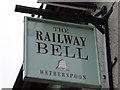
The Railway Bell, inn sign
The Railway Bell, the inn sign of a Wetherspoon pub Image There does seem to be a trend to produce simple pub signs like this. Personally I much prefer traditional inn signs than these bland characterless signs.
Image: © Philip Halling
Taken: 19 Feb 2017
0.03 miles