IMAGES TAKEN NEAR TO
Botany Close, BARNET, EN4 9RX
Introduction
This page details the photographs taken nearby to Botany Close, EN4 9RX by members of the Geograph project.
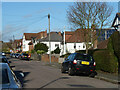
The Geograph project started in 2005 with the aim of publishing, organising and preserving representative images for every square kilometre of Great Britain, Ireland and the Isle of Man.

There are currently over 7.5m images from over14,400 individuals and you can help contribute to the project by visiting https://www.geograph.org.uk
Image Map
Images are licensed for reuse under creativecommons.org/licenses/by-sa/2.0
Notes
- Clicking on the map will re-center to the selected point.
- The higher the marker number, the further away the image location is from the centre of the postcode.
Image Listing (22 Images Found)
Images are licensed for reuse under creativecommons.org/licenses/by-sa/2.0
Image
Details
Distance
2
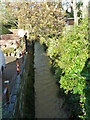
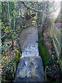
Pymme's Brook
Looking upstream from Mount Road.
Image: © Robin Webster
Taken: 25 Nov 2012
0.07 miles
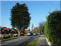
3
Cockfosters: Margaret Road
Viewed looking down the valley towards Pymme's Brook.
Image: © Nigel Cox
Taken: 3 Apr 2006
0.08 miles
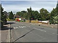
4
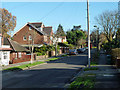
Mount Road
The road bridges Pymme's Brook just beyond the bungalow on the left.
Image: © Robin Webster
Taken: 25 Nov 2012
0.09 miles
5
Weir on Pymme's Brook
Just south of Mount Road.
Image: © Robin Webster
Taken: 25 Nov 2012
0.10 miles
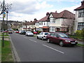
6
Margaret Road, Barnet
Margaret Road in heavy snow.
Image: © Christine Matthews
Taken: 21 Dec 2009
0.11 miles
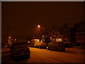
9
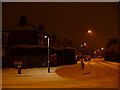
Junction of Margaret Road and Victoria Road, Barnet
Margaret Road during heavy snowfall.
Image: © Christine Matthews
Taken: 21 Dec 2009
0.11 miles
10

Victorian Post Box,Park Road, New Barnet
Image: © Ken Amphlett
Taken: 9 Mar 2003
0.14 miles