IMAGES TAKEN NEAR TO
Leys Gardens, BARNET, EN4 9NA
Introduction
This page details the photographs taken nearby to Leys Gardens, EN4 9NA by members of the Geograph project.
The Geograph project started in 2005 with the aim of publishing, organising and preserving representative images for every square kilometre of Great Britain, Ireland and the Isle of Man.

There are currently over 7.5m images from over14,400 individuals and you can help contribute to the project by visiting https://www.geograph.org.uk
Image Map
Images are licensed for reuse under creativecommons.org/licenses/by-sa/2.0
Notes
- Clicking on the map will re-center to the selected point.
- The higher the marker number, the further away the image location is from the centre of the postcode.
Image Listing (92 Images Found)
Images are licensed for reuse under creativecommons.org/licenses/by-sa/2.0
Image
Details
Distance
1
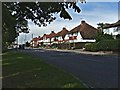
Cat Hill, Cockfosters
View of Cat Hill taken from near the entrance to the Middlesex University.
Image: © Christine Matthews
Taken: 7 Sep 2005
0.06 miles
2
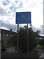
London Borough of Barnet boundary sign
On the western corner of Mansfield Avenue and Cat Hill is this sign indicating the boundary of the London Borough of Barnet. Strangely the signs for entry into the London Borough of Enfield is further east with four houses between the signs. I wonder what borough they are in?
Image: © Christine Matthews
Taken: 29 Mar 2009
0.08 miles
3
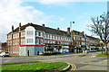
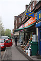
Heddon Court Parade, Cockfosters
One of several large blocks along Cockfosters Road providing a surprising number of shops for this outer suburban area.
Image: © Robin Webster
Taken: 25 Nov 2012
0.08 miles
4
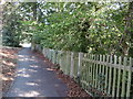
Path alongside Cat Hill
The path leads up to the roundabout at the junction of Cat Hill and Chase Side just ahead. To the right of the fence is Cat Hill Chase Side Pond - see http://www.geograph.org.uk/photo/5120606
This rather elaborately named pond is so-called as Cat Hill (A110) is on this north side and Chase Side (A111) on the east side.
Image: © Marathon
Taken: 14 Sep 2016
0.09 miles
5
Hardware Store
Located in Heddon Park Parade beside Cockfosters Road.
Image: © Martin Addison
Taken: 17 Apr 2009
0.09 miles
6
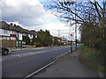
Cat Hill, Cockfosters (A110)
Looking west along Cat Hill towards the roundabout at the junction with Chase Side, Chase Road and the Cockfosters Road. Note the boundary signs for the London Borough of Enfield. Interestingly, they are further west than the Barnet sign, with about four houses in between the signs; are they in Enfield or Barnet?
Image: © Christine Matthews
Taken: 29 Mar 2009
0.09 miles
7
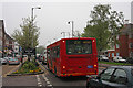
Welcome to Cockfosters
AKA Traffic Jam! This line of traffic stretches from the Cat Hill Roundabout to Cockfosters station and is present for much of the working/shopping of the day.
Image: © Martin Addison
Taken: 17 Apr 2009
0.09 miles
8
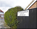
Road sign Mansfield Avenue, Barnet
Looking towards Cat Hill from the east side of Mansfield Avenue.
Image: © Christine Matthews
Taken: 29 Mar 2009
0.09 miles
9

Cat Hill Roundabout, Cockfosters
Looking across towards Cat Hill from the junction of Chase Side at the Cat Hill Roundabout. The old road signs can be seen in front of the block of flats.
Image: © Christine Matthews
Taken: 29 Mar 2009
0.10 miles
10
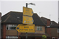
Old Roadsigns at Cat Hill Roundabout
These old style signs for the A111 and A110 roads originally had white paint in the centre area around the wording. Much of it has flaked away revealing the overall yellow of the lower coat.
Image: © Martin Addison
Taken: 17 Apr 2009
0.10 miles