IMAGES TAKEN NEAR TO
Bevan Road, BARNET, EN4 9EA
Introduction
This page details the photographs taken nearby to Bevan Road, EN4 9EA by members of the Geograph project.
The Geograph project started in 2005 with the aim of publishing, organising and preserving representative images for every square kilometre of Great Britain, Ireland and the Isle of Man.

There are currently over 7.5m images from over14,400 individuals and you can help contribute to the project by visiting https://www.geograph.org.uk
Image Map
Images are licensed for reuse under creativecommons.org/licenses/by-sa/2.0
Notes
- Clicking on the map will re-center to the selected point.
- The higher the marker number, the further away the image location is from the centre of the postcode.
Image Listing (167 Images Found)
Images are licensed for reuse under creativecommons.org/licenses/by-sa/2.0
Image
Details
Distance
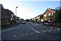
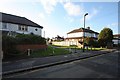
1
Bevan Road, Cockfosters
Housing such as this appeared in the wake of the northward extension of the Piccadilly Line to Cockfosters in 1933. Although the area is actually within the London Borough of Barnet some prefer to describe it as being still in Hertfordshire.
Image: © David Kemp
Taken: 27 Sep 2008
0.05 miles
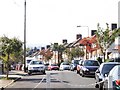
5
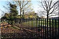
Chalk Lane Cockfosters
Path to Bevan Road
Image: © John Salmon
Taken: 4 Dec 2008
0.08 miles