IMAGES TAKEN NEAR TO
Ridgeway Avenue, BARNET, EN4 8TL
Introduction
This page details the photographs taken nearby to Ridgeway Avenue, EN4 8TL by members of the Geograph project.
The Geograph project started in 2005 with the aim of publishing, organising and preserving representative images for every square kilometre of Great Britain, Ireland and the Isle of Man.

There are currently over 7.5m images from over14,400 individuals and you can help contribute to the project by visiting https://www.geograph.org.uk
Image Map
Images are licensed for reuse under creativecommons.org/licenses/by-sa/2.0
Notes
- Clicking on the map will re-center to the selected point.
- The higher the marker number, the further away the image location is from the centre of the postcode.
Image Listing (29 Images Found)
Images are licensed for reuse under creativecommons.org/licenses/by-sa/2.0
Image
Details
Distance
1
Up the Steps or Down the Slope
This is along the Pymme's Brook Trail in Oak Hill Park, which is also a cycleway. A by pass for bicycles goes around some steps up out of the brookside park.
Image: © Des Blenkinsopp
Taken: 25 Sep 2018
0.06 miles
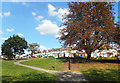
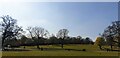
2
Oak Hill Park
View of a footpath that crosses the park and Pymme's Brook from Church Hill Road to Brookside. The houses at the top of the stairs are on Brookside.
Image: © Martin Addison
Taken: 26 Feb 2010
0.06 miles
3
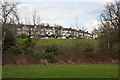
Oak Hill Park
A view across Pymme's Brook towards the houses on Brookside.
Image: © Martin Addison
Taken: 26 Feb 2010
0.07 miles
4
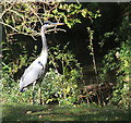
Heron beside Pymme's Brook
Watching me watching him. Considering how herons usually fly off before you get anywhere near them, this one seems totally urbanised and not bothered.
This is in Oak Hill Park.
Image: © Des Blenkinsopp
Taken: 25 Sep 2018
0.10 miles
5
Oakhill Park, Barnet
It was very warm in the park this afternoon.
Image: © Christine Matthews
Taken: 19 Apr 2021
0.11 miles
6
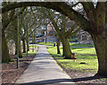
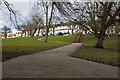
Oak Hill Park
An avenue of Horse Chestnut trees along a footpath across the park. At the end is Church Hill Road.
Image: © Martin Addison
Taken: 26 Feb 2010
0.12 miles
7
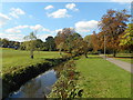
Pymme's Brook in Oak Hill Park
Pymme's Brook is named after William Pymme a local landowner between 1307-1327. It is a tributary of the River Lea.
A long distance path, the Pymme's Brook Trail follows the course of the stream, although not always as closely as this, for 16km from Monken Hadley Common to Edmonton.
Image: © Des Blenkinsopp
Taken: 25 Sep 2018
0.12 miles
8
Pymme's Brook Trail by Oak Hill Park
"Pymmes Brook Trail is located in the London Boroughs of Barnet and Enfield and is just under 16 km long. It is named after William Pymme a local landowner between 1307-1327. The trail is between Monken Hadley Common and the Lee Valley Leisure Complex at Edmonton or alternatively the River Lee Navigation at Pickett's Lock where the trail connects with the Lea Valley Walk. The trail only follows Pymmes Brook approximately as much of it passes through private land which is not open to the public. In its lower urban reaches much of the brook has been culverted to alleviate the risk of flooding." Wikipedia https://en.wikipedia.org/wiki/Pymmes_Brook_Trail
The Brook is down in the trees on the left as the trail goes along a cycleway beside a street appropriately called Brookside.
This section of the trail is largely in parkland and follows the brook more closely than in the lower part.
Image: © Des Blenkinsopp
Taken: 25 Sep 2018
0.13 miles
9

Barnet Bench
Detail of a bench in Oak Hill Park displaying Barnet's coat of arms.
Image: © Martin Addison
Taken: 26 Feb 2010
0.15 miles
10
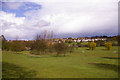
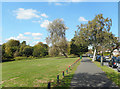
Oakhill Park, East Barnet
Looking across the park in springtime towards East Barnet village.
Image: © Christine Matthews
Taken: 13 Apr 2008
0.15 miles