IMAGES TAKEN NEAR TO
Lakeside Crescent, BARNET, EN4 8QJ
Introduction
This page details the photographs taken nearby to Lakeside Crescent, EN4 8QJ by members of the Geograph project.
The Geograph project started in 2005 with the aim of publishing, organising and preserving representative images for every square kilometre of Great Britain, Ireland and the Isle of Man.

There are currently over 7.5m images from over14,400 individuals and you can help contribute to the project by visiting https://www.geograph.org.uk
Image Map
Images are licensed for reuse under creativecommons.org/licenses/by-sa/2.0
Notes
- Clicking on the map will re-center to the selected point.
- The higher the marker number, the further away the image location is from the centre of the postcode.
Image Listing (35 Images Found)
Images are licensed for reuse under creativecommons.org/licenses/by-sa/2.0
Image
Details
Distance
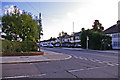
1
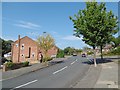
Mansfield Avenue
This is just to the north of Oak Hill Woods Local Nature Reserve. Vernon Crescent is to the right ahead.
Image: © Marathon
Taken: 14 Sep 2016
0.09 miles
2
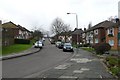
Vernon Crescent East Barnet
A quiet residential backwater on the north side of Oakhill park close to Middlesex University just off Cat Hill.
Image: © Nigel Mykura
Taken: 22 Dec 2008
0.11 miles
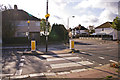
3
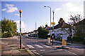
Zebra crossing, Cat Hill, Cockfosters
Looking along Cat Hill towards the Cat Hill Roundabout. The junction with Heddon Court Avenue can be seen on the left.
Image: © Christine Matthews
Taken: 28 Oct 2008
0.12 miles
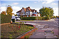
4
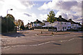
Cat Hill, Cockfosters
Looking across Cat Hill towards Daneland from Heddon Court Avenue.
Image: © Christine Matthews
Taken: 28 Oct 2008
0.12 miles
5

Oak Hill Woods Local Nature Reserve
Oak Hill House was built in 1790 in the grounds of an older mansion called ‘Le Monkefrieth’ which had been there since 1273. Its name meant the monks woodland but Monkfrith was demolished in 1937. Oak Hill is now a theological college.
Oak Hill Woods date back to at least the eleventh century, when it was owned by the church. After the dissolution of the Monasteries it was sold in 1536-38 and remained in private ownership until it was bought by East Barnet Council in 1930. Oak Hill Park was established in 1933.
The small woodland at the northern end of the park is known as Oak Hill Woods Local Nature Reserve. It was declared a Local Nature Reserve in 1997 and is managed by the London Wildlife Trust. It is at least partly ancient woodland suggested by the presence of Wild Service Tree and Midland Hawthorn, and flowers such as wood anemone and yellow archangel.
There is free access to Oak Hill Woods Local Nature Reserve, but not from this small piece of grassland next to Daneland as the woodland edge is impenetrable.
Image: © Marathon
Taken: 14 Sep 2016
0.12 miles
6
Junction of Heddon Court Avenue with Cat Hill, Cockfosters
Looking in the direction of the Cat Hill Roundabout.
Image: © Christine Matthews
Taken: 28 Oct 2008
0.12 miles
7
Zebra crossing, Cat Hill, Cockfosters
Looking across the zebra crossing in Cat Hill towards Daneland from Heddon Court Avenue.
Image: © Christine Matthews
Taken: 28 Oct 2008
0.12 miles
8
Heddon Court Avenue, Cockfosters
Heddon Court Avenue as seen from Cat Hill.
Image: © Christine Matthews
Taken: 28 Oct 2008
0.12 miles
9
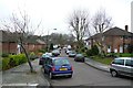
Vernon Crescent East Barnet
View W along this quiet road off Mansfield Avenue
Image: © Nigel Mykura
Taken: 22 Dec 2008
0.13 miles
10
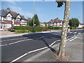
Looking across Cat Hill
Typical suburban Tudorbethan houses can be seen along Cat Hill (A110). Hendon Court Avenue is on the left beyond the pedestrian crossing.
Image: © Marathon
Taken: 14 Sep 2016
0.13 miles