IMAGES TAKEN NEAR TO
Church Hill Road, BARNET, EN4 8PP
Introduction
This page details the photographs taken nearby to Church Hill Road, EN4 8PP by members of the Geograph project.
The Geograph project started in 2005 with the aim of publishing, organising and preserving representative images for every square kilometre of Great Britain, Ireland and the Isle of Man.

There are currently over 7.5m images from over14,400 individuals and you can help contribute to the project by visiting https://www.geograph.org.uk
Image Map
Images are licensed for reuse under creativecommons.org/licenses/by-sa/2.0
Notes
- Clicking on the map will re-center to the selected point.
- The higher the marker number, the further away the image location is from the centre of the postcode.
Image Listing (111 Images Found)
Images are licensed for reuse under creativecommons.org/licenses/by-sa/2.0
Image
Details
Distance
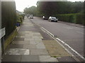
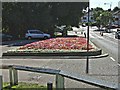
1
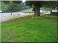
Church Hill Road at the entrance to Oak Hill park
Image: © David Howard
Taken: 25 Sep 2013
0.05 miles
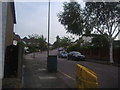
2
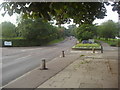
Church Hill Road, East Barnet
At the entrance to Oak Hill Park
Image: © David Howard
Taken: 25 Sep 2013
0.05 miles
6
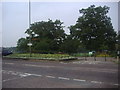
The entrance to Oak Hill Park on Church Hill Road
Image: © David Howard
Taken: 25 Sep 2013
0.08 miles
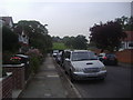
8
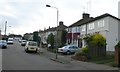
Derwent Avenue, East Barnet
View up Derwent Ave from the junction with Avondale Avenue just off Church Hill Avenue.
Image: © Nigel Mykura
Taken: 22 Dec 2008
0.10 miles
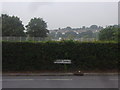
9
Looking East from entrance to Oakhill Park
View from entrance to Oakhill Park in East Barnet Road looking towards junction with Russell lane and Brunswick Park Road.
Image: © Christine Matthews
Taken: 29 Aug 2005
0.11 miles
10
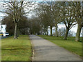
Uphill path, Oak Hill Park
Along the western edge, with Church Hill Road on the left.
Image: © Robin Webster
Taken: 6 Apr 2013
0.12 miles