IMAGES TAKEN NEAR TO
Lancaster Avenue, BARNET, EN4 0EP
Introduction
This page details the photographs taken nearby to Lancaster Avenue, EN4 0EP by members of the Geograph project.
The Geograph project started in 2005 with the aim of publishing, organising and preserving representative images for every square kilometre of Great Britain, Ireland and the Isle of Man.

There are currently over 7.5m images from over14,400 individuals and you can help contribute to the project by visiting https://www.geograph.org.uk
Image Map
Images are licensed for reuse under creativecommons.org/licenses/by-sa/2.0
Notes
- Clicking on the map will re-center to the selected point.
- The higher the marker number, the further away the image location is from the centre of the postcode.
Image Listing (67 Images Found)
Images are licensed for reuse under creativecommons.org/licenses/by-sa/2.0
Image
Details
Distance
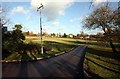
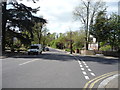
1
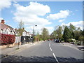
Lancaster Avenue, Hadley Wood
Looking east.
Image: © JThomas
Taken: 15 Apr 2017
0.02 miles
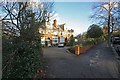
6
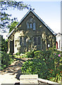
St Paul's Church, Camlet Way, Hadley Wood, Hertfordshire
Another view of St Paul's Church, Camlet Way.
http://www.london.anglican.org/ChurchShow_1820A
Image: © Christine Matthews
Taken: 29 Aug 2005
0.11 miles
7
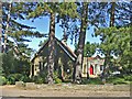
St Paul's Church, Camlet Way, Hadley Wood
View of the church from the south side of Camlet Way.
Image: © Christine Matthews
Taken: 29 Aug 2005
0.12 miles
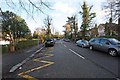
9
Crescent East, Hadley Wood
Looking north west at the junction with Lancaster Avenue.
Image: © JThomas
Taken: 15 Apr 2017
0.12 miles
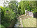
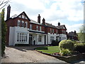
10
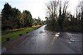
Road from Crescent East to Hadley Wood Tennis Club car park
Image: © John Salmon
Taken: 4 Dec 2008
0.13 miles