IMAGES TAKEN NEAR TO
Cockfosters Road, BARNET, EN4 0DZ
Introduction
This page details the photographs taken nearby to Cockfosters Road, EN4 0DZ by members of the Geograph project.
The Geograph project started in 2005 with the aim of publishing, organising and preserving representative images for every square kilometre of Great Britain, Ireland and the Isle of Man.

There are currently over 7.5m images from over14,400 individuals and you can help contribute to the project by visiting https://www.geograph.org.uk
Image Map
Images are licensed for reuse under creativecommons.org/licenses/by-sa/2.0
Notes
- Clicking on the map will re-center to the selected point.
- The higher the marker number, the further away the image location is from the centre of the postcode.
Image Listing (209 Images Found)
Images are licensed for reuse under creativecommons.org/licenses/by-sa/2.0
Image
Details
Distance
1

Petrol Station, Cockfosters Road, Cockfosters, Hertfordshire
Looking along the Cockfosters Road (A111) we have this Jet Petrol Station opposite Cockfosters Cricket Ground.
Image: © Christine Matthews
Taken: 1 Jul 2008
0.00 miles
2

Cockfosters tube station - entrance from car park
See Image
Image: © Mike Quinn
Taken: 5 Apr 2017
0.01 miles
3

Chalk Lane, Cockfosters, Hertfordshire
Corner of Chalk Lane hear junction with Cockfosters Road. One of the entrances to Cockfosters Tube station can be seen on the left.
Image: © Christine Matthews
Taken: 1 Jul 2008
0.02 miles
4

Cockfosters tube station - (former) public telephone booths
See Image The telephones have gone, but I guess that the booths are preserved because the building is Grade II listed.
Image: © Mike Quinn
Taken: 5 Apr 2017
0.02 miles

6
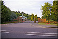
Entrance to Trent Park Cemetery, Cockfosters Road, Cockfosters, Hertfordshire
Trent Park Cemetery, in Cockfosters, was opened in 1960. It was designed as a lawn cemetery with a selection of bronze plaque memorials. It also has its own burial chapel with a book of remembrance.
This view is from the other side of the Cockfosters Road near the Cricket Ground.
Image: © Christine Matthews
Taken: 1 Jul 2008
0.02 miles
7

Cockfosters station
Opened in 1933 when the Piccadilly Line was extended to terminate here. A pedestrian subway runs under the road, with a small bus station on this side.
Image: © Robin Webster
Taken: 25 Nov 2012
0.03 miles
8

Cockfosters Station
On the London Underground. The northern terminus on the Piccadilly Line.
Image: © JThomas
Taken: 3 Sep 2016
0.03 miles
9

Cockfosters tube station - UNDERGROUND sign
Image: © Mike Quinn
Taken: 5 Apr 2017
0.03 miles