IMAGES TAKEN NEAR TO
Millmarsh Lane, ENFIELD, EN3 7UY
Introduction
This page details the photographs taken nearby to Millmarsh Lane, EN3 7UY by members of the Geograph project.
The Geograph project started in 2005 with the aim of publishing, organising and preserving representative images for every square kilometre of Great Britain, Ireland and the Isle of Man.

There are currently over 7.5m images from over14,400 individuals and you can help contribute to the project by visiting https://www.geograph.org.uk
Image Map
Images are licensed for reuse under creativecommons.org/licenses/by-sa/2.0
Notes
- Clicking on the map will re-center to the selected point.
- The higher the marker number, the further away the image location is from the centre of the postcode.
Image Listing (14 Images Found)
Images are licensed for reuse under creativecommons.org/licenses/by-sa/2.0
Image
Details
Distance

2
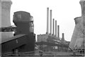
Brimsdown Power Station, 1975
From the north
Image: © Pierre Terre
Taken: Unknown
0.13 miles
3
Brimsdown Power Station 1975
From the towpath to the south
Image: © Pierre Terre
Taken: Unknown
0.15 miles
4

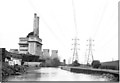
Industrial area at Brimsdown, Enfield
Industrial area at Brimsdown, with River Lea and electricity pylons. Taken in the winter with the late afternoon sun shining off the cylindrical storage areas.
Image: © Christine Matthews
Taken: Unknown
0.18 miles

6

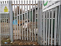
Boundary Fence of Industrial Area backing on to River Lea
Boundary fence of industrial area - Brimsdown - backing on to the River Lea.
Image: © Christine Matthews
Taken: Unknown
0.21 miles
9
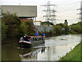
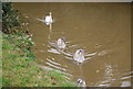
'Tarporley' heads south
All of the few boats encountered on the Lee Navigation were heading south.
Image: © Robin Webster
Taken: 20 Oct 2012
0.24 miles