IMAGES TAKEN NEAR TO
Jeffreys Road, ENFIELD, EN3 7UA
Introduction
This page details the photographs taken nearby to Jeffreys Road, EN3 7UA by members of the Geograph project.
The Geograph project started in 2005 with the aim of publishing, organising and preserving representative images for every square kilometre of Great Britain, Ireland and the Isle of Man.

There are currently over 7.5m images from over14,400 individuals and you can help contribute to the project by visiting https://www.geograph.org.uk
Image Map
Images are licensed for reuse under creativecommons.org/licenses/by-sa/2.0
Notes
- Clicking on the map will re-center to the selected point.
- The higher the marker number, the further away the image location is from the centre of the postcode.
Image Listing (27 Images Found)
Images are licensed for reuse under creativecommons.org/licenses/by-sa/2.0
Image
Details
Distance
1
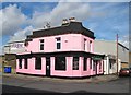
Ponders End: The Granville
Now pretty in pink The Granville once served a small neighbourhood of houses where workers at the Ponders End jute mill at the end of Duck Lees Lane lived. The jute mill was short-lived and in 1886 the Ediswan Company (formed by Thomas Edison and Joseph Swan) took over the building and converted it into a factory manufacturing electric light bulbs. The factory continued production until 1969, and was demolished shortly afterwards.
Today all the Victorian workers' houses in Northampton Road, to the right of the pub in the photograph, and Alpha Road at the end of the Screwfix building, have gone, the area having being swallowed up by the Ponders End Industrial Estate development, leaving the Victorian Granville as a sole reminder of an aspect of Enfield's industrial past.
The pub was briefly closed in 2008 and 2009 but is now open again.
Image: © Nigel Cox
Taken: 6 Oct 2010
0.15 miles
3
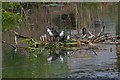
New Family
A family of young Moorhens on the Lea and Stort navigation
Image: © Glyn Baker
Taken: 30 Jun 2006
0.15 miles
4
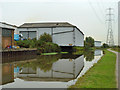
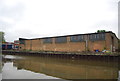
Covered wharf, Lee Navigation
Although the premises are in use, the wharf is not.
Image: © Robin Webster
Taken: 20 Oct 2012
0.16 miles
6
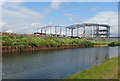
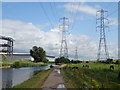
Construction, Lea Valley
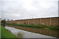
New industrial units being built beside the River Lea Navigation.
Image: © JThomas
Taken: 20 Jul 2019
0.18 miles
7
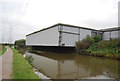
Lee Navigation Near Ponders End
Looking downstream.
Image: © Glyn Baker
Taken: 28 Apr 2016
0.18 miles
8
National Cycle Route 1, River Lea Valley
Beside the River Lea Navigation.
Image: © JThomas
Taken: 20 Jul 2019
0.18 miles
9
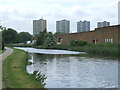
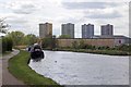
River Lee Navigation at Ponders End
The River Lee Navigation at Ponders End, in North London's outer suburbs. Industrial units line the far bank of the waterway.
The towpath is shared by walkers and cyclists. It forms part of National Cycle Network route 1.
Image: © Malc McDonald
Taken: 1 Jun 2013
0.18 miles