IMAGES TAKEN NEAR TO
East Duck Lees Lane, ENFIELD, EN3 7SS
Introduction
This page details the photographs taken nearby to East Duck Lees Lane, EN3 7SS by members of the Geograph project.
The Geograph project started in 2005 with the aim of publishing, organising and preserving representative images for every square kilometre of Great Britain, Ireland and the Isle of Man.

There are currently over 7.5m images from over14,400 individuals and you can help contribute to the project by visiting https://www.geograph.org.uk
Image Map
Images are licensed for reuse under creativecommons.org/licenses/by-sa/2.0
Notes
- Clicking on the map will re-center to the selected point.
- The higher the marker number, the further away the image location is from the centre of the postcode.
Image Listing (38 Images Found)
Images are licensed for reuse under creativecommons.org/licenses/by-sa/2.0
Image
Details
Distance
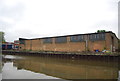
1
Covered wharf, Lee Navigation
Although the premises are in use, the wharf is not.
Image: © Robin Webster
Taken: 20 Oct 2012
0.04 miles
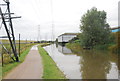
3
National Cycle Route 1, River Lea Valley
Beside the River Lea Navigation.
Image: © JThomas
Taken: 20 Jul 2019
0.06 miles
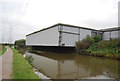
4
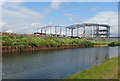
Construction, Lea Valley
New industrial units being built beside the River Lea Navigation.
Image: © JThomas
Taken: 20 Jul 2019
0.07 miles
5

Rough Pasture in Lea Valley Park
A long strip of grazing land sandwiched between the River Lea Navigation and King George's Reservoir
Image: © Chris Heaton
Taken: 3 Sep 2017
0.07 miles
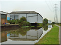
7

Grazing beside the River Lea Navigation
Strip of land towards the King George's Reservoir.
Image: © JThomas
Taken: 20 Jul 2019
0.09 miles
8
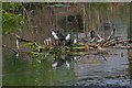
New Family
A family of young Moorhens on the Lea and Stort navigation
Image: © Glyn Baker
Taken: 30 Jun 2006
0.09 miles
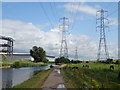
9
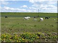
Horses and ponies in front of King George's Reservoir
Beyond the horses and poniest is the embankment of King George's Reservoir. The excavation and building of the surrounding embankment of the reservoir, nearly five miles in length, was carried out almost entirely by a manual labour force of 1,000 navvies, and the surplus excavated clay was spread over part of Hackney Marsh. In 1913 King George Vth and Queen Mary named the reservoir and pressed the buttons allowing water from the River Lea to start flowing into the storage bowl.
The view is from the towpath of the River Lee Navigation.
Image: © Marathon
Taken: 19 Apr 2017
0.10 miles