IMAGES TAKEN NEAR TO
Lockfield Avenue, ENFIELD, EN3 7JY
Introduction
This page details the photographs taken nearby to Lockfield Avenue, EN3 7JY by members of the Geograph project.
The Geograph project started in 2005 with the aim of publishing, organising and preserving representative images for every square kilometre of Great Britain, Ireland and the Isle of Man.

There are currently over 7.5m images from over14,400 individuals and you can help contribute to the project by visiting https://www.geograph.org.uk
Image Map
Images are licensed for reuse under creativecommons.org/licenses/by-sa/2.0
Notes
- Clicking on the map will re-center to the selected point.
- The higher the marker number, the further away the image location is from the centre of the postcode.
Image Listing (11 Images Found)
Images are licensed for reuse under creativecommons.org/licenses/by-sa/2.0
Image
Details
Distance

2
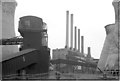
Brimsdown Power Station, 1975
From the north
Image: © Pierre Terre
Taken: Unknown
0.17 miles
3
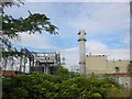
Gas Fired Electricity Generating station Brimsdown
Visually I would have liked to see the stack slightly divorced from the bulk of the cladding.
However it is a simple solution to an industrial
giant.
Image: © Jack Hill
Taken: 9 Aug 2005
0.21 miles
4
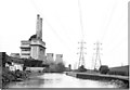
Brimsdown Power Station 1975
From the towpath to the south
Image: © Pierre Terre
Taken: Unknown
0.22 miles
5
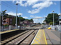
Brimsdown station
The railway line from Stratford to Broxbourne via Waltham Cross was opened by the Northern & Eastern Railway on 15th September 1840. Brimsdown station was financed by a local landowner and developer, and opened on 1st October 1884. The lines through Brimsdown were electrified on 5th May 1969.
Just ahead is the level crossing where the line crosses Green Street. The view over the crossing can be seen at http://www.geograph.org.uk/photo/5460108 This is the up platform but the next station in this down direction is Enfield Lock.
Image: © Marathon
Taken: 12 Jul 2017
0.22 miles
6
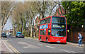
Brimsdown Avenue
Looking north along this road that parallels the Liverpool Street to Cambridge line through this part of Enfield. On the right, a 191 bus from Edmonton Green has terminated and another on the route can be seen in the far distance. After dropping off the passengers the buses will use the terminus of the 307 route on Green Street as a turn round before heading back up Brimsdown Avenue.
Image: © Martin Addison
Taken: 24 Apr 2010
0.23 miles
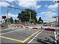
7
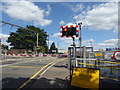
The level crossing at Brimsdown station
The railway line from Stratford to Broxbourne via Waltham Cross was opened by the Northern & Eastern Railway on 15th September 1840. Brimsdown station was financed by a local landowner and developer, and opened on 1st October 1884. The lines through Brimsdown were electrified on 5th May 1969.
This is the level crossing where the line crosses Green Street. The station is just to the right. The view over the crossing from the station can be seen at http://www.geograph.org.uk/photo/5460117
Image: © Marathon
Taken: 12 Jul 2017
0.24 miles
8
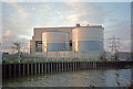
Industrial area at Brimsdown, Enfield
Industrial area at Brimsdown, with River Lea and electricity pylons. Taken in the winter with the late afternoon sun shining off the cylindrical storage areas.
Image: © Christine Matthews
Taken: Unknown
0.24 miles
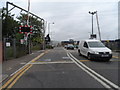
10
Green Street level crossing alongside Brimsdown station
The railway line from Stratford to Broxbourne via Waltham Cross was opened by the Northern & Eastern Railway on 15th September 1840. Brimsdown station was financed by a local landowner and developer, and opened on 1st October 1884. The lines through Brimsdown were electrified on 5th May 1969.
This is the level crossing where the line crosses Green Street. The station is just to the right. The view over the crossing from the station can be seen at http://www.geograph.org.uk/photo/5460117
Image: © Marathon
Taken: 12 Jul 2017
0.24 miles