IMAGES TAKEN NEAR TO
The Ride, ENFIELD, EN3 7EE
Introduction
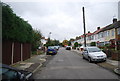
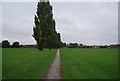
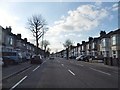
This page details the photographs taken nearby to The Ride, EN3 7EE by members of the Geograph project.
The Geograph project started in 2005 with the aim of publishing, organising and preserving representative images for every square kilometre of Great Britain, Ireland and the Isle of Man.

There are currently over 7.5m images from over14,400 individuals and you can help contribute to the project by visiting https://www.geograph.org.uk
Image Map
Images are licensed for reuse under creativecommons.org/licenses/by-sa/2.0
Notes
- Clicking on the map will re-center to the selected point.
- The higher the marker number, the further away the image location is from the centre of the postcode.
Image Listing (15 Images Found)
Images are licensed for reuse under creativecommons.org/licenses/by-sa/2.0
Image
Details
Distance
1
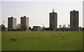
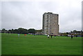
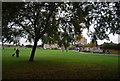
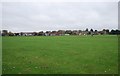
Durants Park
A view across this park in the London Borough of Enfield. The tower blocks are on Exeter Road. The more distant ones are on Napier Road. The advent of spring has brought the Crows together in flocks.
The park is named after one of the eight sub-manors of the Enfield estate - gifted to Geoffrey de Mandeville by William the Conqueror. Information from http://www.parkexplorer.org.uk/index.htm.
Image: © Martin Addison
Taken: 24 Apr 2010
0.09 miles