IMAGES TAKEN NEAR TO
The Ride, ENFIELD, EN3 7DL
Introduction
This page details the photographs taken nearby to The Ride, EN3 7DL by members of the Geograph project.
The Geograph project started in 2005 with the aim of publishing, organising and preserving representative images for every square kilometre of Great Britain, Ireland and the Isle of Man.

There are currently over 7.5m images from over14,400 individuals and you can help contribute to the project by visiting https://www.geograph.org.uk
Image Map
Images are licensed for reuse under creativecommons.org/licenses/by-sa/2.0
Notes
- Clicking on the map will re-center to the selected point.
- The higher the marker number, the further away the image location is from the centre of the postcode.
Image Listing (29 Images Found)
Images are licensed for reuse under creativecommons.org/licenses/by-sa/2.0
Image
Details
Distance
7
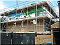
House being built in rear garden of 331 High Street
Image: © Alex McGregor
Taken: 20 Aug 2014
0.15 miles
8
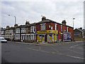
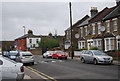
Hertford Road, Ponders End
Looking across the Hertford Road towards the junction with Durants Road.
Image: © Christine Matthews
Taken: 11 Mar 2009
0.15 miles