IMAGES TAKEN NEAR TO
Fogerty Close, ENFIELD, EN3 6XJ
Introduction
This page details the photographs taken nearby to Fogerty Close, EN3 6XJ by members of the Geograph project.
The Geograph project started in 2005 with the aim of publishing, organising and preserving representative images for every square kilometre of Great Britain, Ireland and the Isle of Man.

There are currently over 7.5m images from over14,400 individuals and you can help contribute to the project by visiting https://www.geograph.org.uk
Image Map
Images are licensed for reuse under creativecommons.org/licenses/by-sa/2.0
Notes
- Clicking on the map will re-center to the selected point.
- The higher the marker number, the further away the image location is from the centre of the postcode.
Image Listing (26 Images Found)
Images are licensed for reuse under creativecommons.org/licenses/by-sa/2.0
Image
Details
Distance
2
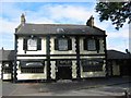
Rifles Pub at Enfield Island Village
The colour scheme for this pub indicates a case of being upmarket despite the litter in the car park adjacent.
Image: © Jack Hill
Taken: 9 Aug 2005
0.08 miles
3
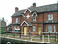
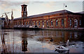
Enfield Lock
The Lee Conservancy office at Enfield Lock on the River Lee Navigation
Image: © Stephen Dawson
Taken: 4 Apr 2004
0.08 miles
4
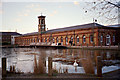
Old Machine Shop, Enfield Island Village
A late afternoon winter shot of the Old Machine Shop, Enfield Island Village, with the River Lee Basin partially frozen.
Image: © Christine Matthews
Taken: Unknown
0.15 miles
5
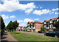
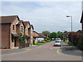
George Lovell Drive
This is part of the extensive new housing developments at Enfield Island Village, once the site of the Royal Small Arms Factory.
George Lovell was Government Inspector of Small Arms in the mid 19th century and oversaw much needed improvements to the design and production of the muskets used by the British Army at that time.
Image: © Des Blenkinsopp
Taken: 24 Jul 2014
0.15 miles
6
Old Machine Shop, Enfield Island Village
The Old Machine Shop, Enfield Island Village, with the River Lee Basin. This image taken in January shows the partially frozen basin with wildfowl in late afternoon sunlight.
Image: © Christine Matthews
Taken: Unknown
0.15 miles
7
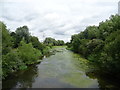
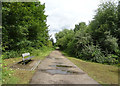
Rammey Marsh Flood Relief Channel
The main flood channel for the River Lea.
View from a bridge on National Cycle Route 1.
Image: © JThomas
Taken: 20 Jul 2019
0.15 miles
8

River Lee Basin, Enfield Island Village
The River Lee Basin near the Old Machine Shop, Enfield Island Village. The image was taken in the winter when the water was partially frozen. Swans and ducks can be seen in this late afternoon shot.
Image: © Christine Matthews
Taken: Unknown
0.16 miles
9
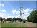
Pylons & Playground
These cables run the length of Enfield Island Village and the land beneath has been made into park and cycleways.
Image: © Des Blenkinsopp
Taken: 24 Jul 2014
0.16 miles
10
Blanchard Grove, Enfield Island Village
New housing on the outskirts of Greater London.
Image: © Malc McDonald
Taken: 1 Jun 2013
0.18 miles