IMAGES TAKEN NEAR TO
Kettering Road, ENFIELD, EN3 6XA
Introduction
This page details the photographs taken nearby to Kettering Road, EN3 6XA by members of the Geograph project.
The Geograph project started in 2005 with the aim of publishing, organising and preserving representative images for every square kilometre of Great Britain, Ireland and the Isle of Man.

There are currently over 7.5m images from over14,400 individuals and you can help contribute to the project by visiting https://www.geograph.org.uk
Image Map
Images are licensed for reuse under creativecommons.org/licenses/by-sa/2.0
Notes
- Clicking on the map will re-center to the selected point.
- The higher the marker number, the further away the image location is from the centre of the postcode.
Image Listing (49 Images Found)
Images are licensed for reuse under creativecommons.org/licenses/by-sa/2.0
Image
Details
Distance
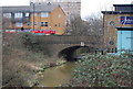
5
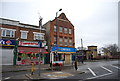
Turkey Brook by Hertford Road, Freezywater
Image: © David Howard
Taken: 23 Oct 2014
0.08 miles
9
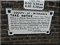
Old sign on the Turkey Brook bridge, Hertford Road
Oddly I found the identical one last week in Palmers Green and spotted this one totally by chance. http://www.geograph.org.uk/photo/4207661 Before 1933 most bridge signs were issued by the owners, ie railways, waterways and councils, so these were basically the same as a national version at the time.
Image: © David Howard
Taken: 23 Oct 2014
0.09 miles