IMAGES TAKEN NEAR TO
Burton Drive, ENFIELD, EN3 6WW
Introduction
This page details the photographs taken nearby to Burton Drive, EN3 6WW by members of the Geograph project.
The Geograph project started in 2005 with the aim of publishing, organising and preserving representative images for every square kilometre of Great Britain, Ireland and the Isle of Man.

There are currently over 7.5m images from over14,400 individuals and you can help contribute to the project by visiting https://www.geograph.org.uk
Image Map
Images are licensed for reuse under creativecommons.org/licenses/by-sa/2.0
Notes
- Clicking on the map will re-center to the selected point.
- The higher the marker number, the further away the image location is from the centre of the postcode.
Image Listing (98 Images Found)
Images are licensed for reuse under creativecommons.org/licenses/by-sa/2.0
Image
Details
Distance
1

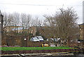
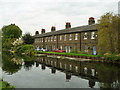
River Lee Navigation with Government Row cottages and cycle track
Looking towards the setting sun with a cyclist on the cycle track alongside the River Lee Navigation with the Government Row houses which were originally built to house the workers as the Small Arms Factory on the site which is now the Enfield Island Village Estate.
Image: © Christine Matthews
Taken: Unknown
0.03 miles
4
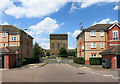
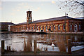
Water Tower, Enfield Island Village
Enfield Island Village is a new residential area on land which was formerly the Royal Small Arms Factory.
Various structures from the old factory have been retained in the new development.
Image: © Des Blenkinsopp
Taken: 24 Jul 2014
0.05 miles
5
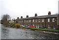
Government Row
Housing for the Royal Small Arms Factory.
Image: © N Chadwick
Taken: 3 Feb 2013
0.05 miles
6
Terrace on Government Row
One of several terraces on the Row, running along the bank of the Lee Navigation and formerly housing workers in the small arms works that was once here.
Image: © Robin Webster
Taken: 20 Oct 2012
0.05 miles
7

Enfield Island Village Library
This new library is part of the transformation of the former Royal Small Arms Factory site into a residential area.
Image: © Des Blenkinsopp
Taken: 24 Jul 2014
0.06 miles
9
Old Machine Shop, Enfield Island Village
A late afternoon winter shot of the Old Machine Shop, Enfield Island Village, with the River Lee Basin partially frozen.
Image: © Christine Matthews
Taken: Unknown
0.07 miles
10
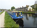
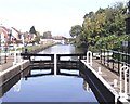
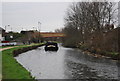
Narrowboat Jessica on the River Lee Navigation near Enfield Lock
The original River Lea flowed 70 miles from Leagrove Marsh near Luton to the River Thames at Bow Creek. The River Lee Act of 1766 provided for the construction of 15 new cuts to straighten the course of the river by eliminating loops which made it difficult to navigate. This is one of those cuts and hence it is a navigation rather than a river. The Lea passes just the other side of these workers' cottages. Historically the river is spelled Lea while the navigation is Lee.
Beyond the River Lea is the new development of Enfield Island Village on the site of the former Royal Arms Factory which was given its formal title in 1854 and manufactured the famous Lee Enfield rifle which linked the two names associated with the spot. The towpath here runs alongside South Ordnance Road which is just down the bank on the left.
Image: © Marathon
Taken: 27 Sep 2017
0.07 miles