IMAGES TAKEN NEAR TO
Park Road, ENFIELD, EN3 6LL
Introduction
This page details the photographs taken nearby to Park Road, EN3 6LL by members of the Geograph project.
The Geograph project started in 2005 with the aim of publishing, organising and preserving representative images for every square kilometre of Great Britain, Ireland and the Isle of Man.

There are currently over 7.5m images from over14,400 individuals and you can help contribute to the project by visiting https://www.geograph.org.uk
Image Map
Images are licensed for reuse under creativecommons.org/licenses/by-sa/2.0
Notes
- Clicking on the map will re-center to the selected point.
- The higher the marker number, the further away the image location is from the centre of the postcode.
Image Listing (7 Images Found)
Images are licensed for reuse under creativecommons.org/licenses/by-sa/2.0
Image
Details
Distance
1
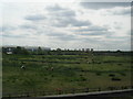
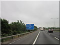
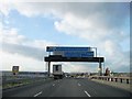
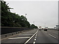
Land by the M25
A view from a different direction of Image, seen from the railway line between Waltham Cross and Enfield Lock. The M25 is on the left; a blue sign on the motorway can just be made out on the extreme left. The trees and streetlamps on the right mark the course of the A1055.
Image: © Derek Harper
Taken: 2 Aug 2012
0.06 miles
7
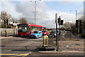
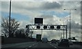
Mollison Avenue
The A1055 seen at the junction with the A1010. This A road connects the A10 to the industrial estates along the northern Lea Valley and beside King George's Reservoir.
Image: © Martin Addison
Taken: 12 Feb 2011
0.25 miles