IMAGES TAKEN NEAR TO
King Henrys Mews, ENFIELD, EN3 6JS
Introduction
This page details the photographs taken nearby to King Henrys Mews, EN3 6JS by members of the Geograph project.
The Geograph project started in 2005 with the aim of publishing, organising and preserving representative images for every square kilometre of Great Britain, Ireland and the Isle of Man.

There are currently over 7.5m images from over14,400 individuals and you can help contribute to the project by visiting https://www.geograph.org.uk
Image Map
Images are licensed for reuse under creativecommons.org/licenses/by-sa/2.0
Notes
- Clicking on the map will re-center to the selected point.
- The higher the marker number, the further away the image location is from the centre of the postcode.
Image Listing (82 Images Found)
Images are licensed for reuse under creativecommons.org/licenses/by-sa/2.0
Image
Details
Distance
2
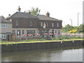
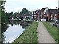
The Greyhound, Enfield
A canalside pub on the Lea Navigation. It probably benefits from trade on the newish estate on Enfield Island Village accessed by the adjacent bridge Image (the bridge approach can be seen at the right of the photo).
Image: © Stephen Craven
Taken: 2 May 2009
0.04 miles
3
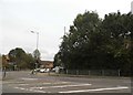
Ordnance Road at the junction of Mollison Avenue
Image: © David Howard
Taken: 23 Oct 2014
0.04 miles
4
Ordnance Road at the junction of Mollison Avenue
Mollison Avenue was extended from just south of here and upgraded to a dual carriageway in around the 80s to reach Hertford Road and allow traffic to bypass the small local roads between the North Circular and Waltham Cross.
Image: © David Howard
Taken: 23 Oct 2014
0.05 miles
5
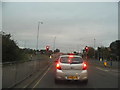
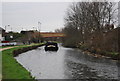
River Lee Navigation near Enfield Lock
Image: © Malc McDonald
Taken: 1 Jun 2013
0.05 miles
9
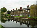
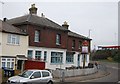
Terrace on Government Row
One of several terraces on the Row, running along the bank of the Lee Navigation and formerly housing workers in the small arms works that was once here.
Image: © Robin Webster
Taken: 20 Oct 2012
0.07 miles
10
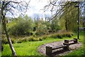
Small Pond near Enfield Lock
This public open space is sited between the A1055 & Warwick Road.
Image: © Glyn Baker
Taken: 28 Apr 2016
0.07 miles