IMAGES TAKEN NEAR TO
Harston Drive, ENFIELD, EN3 6GJ
Introduction
This page details the photographs taken nearby to Harston Drive, EN3 6GJ by members of the Geograph project.
The Geograph project started in 2005 with the aim of publishing, organising and preserving representative images for every square kilometre of Great Britain, Ireland and the Isle of Man.

There are currently over 7.5m images from over14,400 individuals and you can help contribute to the project by visiting https://www.geograph.org.uk
Image Map
Images are licensed for reuse under creativecommons.org/licenses/by-sa/2.0
Notes
- Clicking on the map will re-center to the selected point.
- The higher the marker number, the further away the image location is from the centre of the postcode.
Image Listing (111 Images Found)
Images are licensed for reuse under creativecommons.org/licenses/by-sa/2.0
Image
Details
Distance
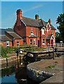
1
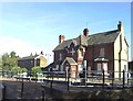
Enfield Lock
When first Geographed in 2004, the Lee Conservancy building was still occupied. However, four years on it stands boarded up and empty.
Image: © David Kemp
Taken: 11 Oct 2008
0.02 miles
2
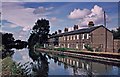
Government Row, Enfield Lock
These cottages were originally homes for the workers in the Small Arms Factory. The Enfield Island Village Estate has been developed on the site of the Small Arms Factory since this photograph was taken
Image: © Christine Matthews
Taken: Unknown
0.03 miles
6
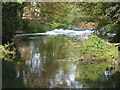
Weir on the River Lea
The original River Lea flowed 70 miles from Leagrove Marsh near Luton to the River Thames at Bow Creek. The River Lee Act of 1766 provided for the construction of 15 new cuts to straighten the course of the river by eliminating loops which made it difficult to navigate. The River Lee Navigation just west of here at Enfield Lock is one of those cuts and hence it is a navigation rather than a river. This though is the River Lea which unlike the Lee Navigation is not accessible here. Historically the river is spelled Lea while the navigation is Lee.
The London LOOP follows the River Lea here for a short distance after descending into the Lea Valley from Epping Forest.
Image: © Marathon
Taken: 27 Sep 2017
0.04 miles
7
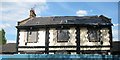
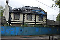
Rifles, Enfield - now derelict
The pub described as 'upmarket' four years ago Image had not survived the first year of the recession.
Image: © Stephen Craven
Taken: 2 May 2009
0.04 miles
8
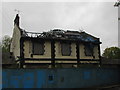
Derelict House in Enfield Island Village
Image: © Matthew Chadwick
Taken: 21 Oct 2012
0.04 miles
9
Enfield Island Village
The area has been redeveloped from the factories where rifles and bayonets were manufactured into a business park and residential accommodation.
Image: © Jack Hill
Taken: 9 Aug 2005
0.05 miles
10
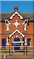
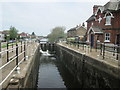
Former Lee Conservancy Board toll office, Enfield Lock
Built in 1889.
Image: © Jim Osley
Taken: 6 Jun 2016
0.05 miles