IMAGES TAKEN NEAR TO
Tysoe Avenue, ENFIELD, EN3 6FL
Introduction
This page details the photographs taken nearby to Tysoe Avenue, EN3 6FL by members of the Geograph project.
The Geograph project started in 2005 with the aim of publishing, organising and preserving representative images for every square kilometre of Great Britain, Ireland and the Isle of Man.

There are currently over 7.5m images from over14,400 individuals and you can help contribute to the project by visiting https://www.geograph.org.uk
Image Map
Images are licensed for reuse under creativecommons.org/licenses/by-sa/2.0
Notes
- Clicking on the map will re-center to the selected point.
- The higher the marker number, the further away the image location is from the centre of the postcode.
Image Listing (14 Images Found)
Images are licensed for reuse under creativecommons.org/licenses/by-sa/2.0
Image
Details
Distance
2
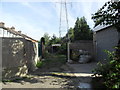
Enfield Lock
Alley behind Tysoe Avenue.
Image: © Burgess Von Thunen
Taken: 6 Sep 2012
0.10 miles
3
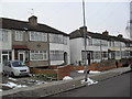
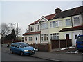
Tysoe Avenue
1930s terraces in Enfield Lock.
Image: © Burgess Von Thunen
Taken: 9 Feb 2012
0.12 miles
4
Tysoe Avenue
1930s terraces in Enfield Lock.
Image: © Burgess Von Thunen
Taken: 6 Sep 2012
0.14 miles
5
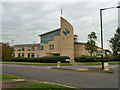
Bic, Innova Park
Not the ballpoint pen, but Business Innovation Centre. It is for sale.
Image: © Robin Webster
Taken: 20 Oct 2012
0.19 miles
6
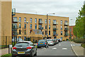
Flats, Kinetic Crescent
On Innova Park, a development with industry to the north and high density housing to the south.
Image: © Robin Webster
Taken: 20 Oct 2012
0.20 miles
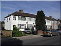
7
Newbury Avenue
A Vauxhall Corsa C on the corner of Ordnance Road.
Image: © Burgess Von Thunen
Taken: 9 Feb 2012
0.23 miles
8

Warehouse, Innova Park
Innova Park is an industrial park, focussed principally on distribution and warehousing. This is the Deluxe Media Services warehouse.
Image: © Stephen Dawson
Taken: 15 May 2005
0.23 miles
9
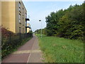
Path along the edge of the new estate around the Oasis Academy
There is a large private lake between Mollison Avenue and the Innova Business Park which includes the new estate around the Oasis Academy. The lake was once much larger when it was on Rammey Marsh but that was before Mollison Way was constructed and most of Rammey Marsh to the west of Mollison Way was built on. The lake is now used for private water sports. In this photograph of the path along the edge of the estate, the lake is beyond the trees on the right.
Image: © Marathon
Taken: 27 Sep 2017
0.24 miles
10
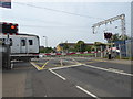
Approaching Enfield Lock station
The railway line from Stratford to Broxbourne via Waltham Cross was opened by the Northern & Eastern Railway on 15th September 1840. Enfield Lock station was opened by the Eastern Counties Railway in 1855 as Ordnance Factory, and later renamed in 1886 to Enfield Lock. The lines through Enfield Lock were electrified on 5th May 1969.
Enfield Lock was the main station for the Royal Small Arms Factory until its closure in the late 1980s, and now serves the large housing development on the site known as Enfield Island Village, as well as the nearby Innova Science and Business Park.
This view is looking across the level crossing on Ordnance Road next to the station as a train bound for Liverpool Street slows down ready to stop.
Image: © Marathon
Taken: 27 Sep 2017
0.24 miles