IMAGES TAKEN NEAR TO
Hertford Road, ENFIELD, EN3 5UT
Introduction
This page details the photographs taken nearby to Hertford Road, EN3 5UT by members of the Geograph project.
The Geograph project started in 2005 with the aim of publishing, organising and preserving representative images for every square kilometre of Great Britain, Ireland and the Isle of Man.

There are currently over 7.5m images from over14,400 individuals and you can help contribute to the project by visiting https://www.geograph.org.uk
Image Map
Images are licensed for reuse under creativecommons.org/licenses/by-sa/2.0
Notes
- Clicking on the map will re-center to the selected point.
- The higher the marker number, the further away the image location is from the centre of the postcode.
Image Listing (12 Images Found)
Images are licensed for reuse under creativecommons.org/licenses/by-sa/2.0
Image
Details
Distance
1
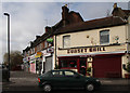
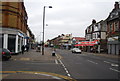
Sunset grill
Part of a parade of shops on the corner of Hoe Lane and Hertford Road.
Image: © Martin Addison
Taken: 12 Feb 2011
0.04 miles
2
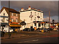
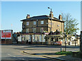
Bar FM
Nineteenth Century pub previously called "The Bell"
Image: © archimandrill
Taken: 19 Feb 2009
0.06 miles
3
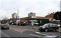
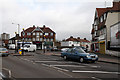
Hertford Road
The Esso service station at the junction with Ingersoll Road, complete with Tesco Express store. A driver has pulled out to the middle of the road awaiting a break in the steady stream of northbound traffic along the A1010. The tower blocks behind the service station are on the Eastfield Road Estate and were built in the late 1960's.
Image: © Martin Addison
Taken: 12 Feb 2011
0.06 miles
5
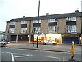
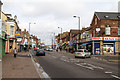
Hertford Road
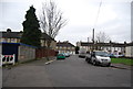
Seen at the junction with Albany Park Avenue. Two small matching parades of shops with flats above are set at 45 degrees to the road. The volume of traffic along the busy A1010 has virtually erased the marking of the zebra crossing, though the centre hatching lines look to have been recently repainted.
Image: © Martin Addison
Taken: 12 Feb 2011
0.18 miles
6
Hertford Road
The A1010 seen in the area of Enfield Wash. The road climbs to cross Turkey Brook. On the left is Grove Road West and on the right is Albany Road.
Image: © Martin Addison
Taken: 12 Feb 2011
0.22 miles
8
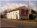
The Arras Club
Social club originally founded for veterans of the First World War.
Image: © archimandrill
Taken: 19 Feb 2009
0.23 miles
10
The Red Lion, Enfield Highway
On Hertford Road.
Image: © Robin Webster
Taken: 11 Nov 2012
0.24 miles