IMAGES TAKEN NEAR TO
Longfield Avenue, ENFIELD, EN3 5RU
Introduction
This page details the photographs taken nearby to Longfield Avenue, EN3 5RU by members of the Geograph project.
The Geograph project started in 2005 with the aim of publishing, organising and preserving representative images for every square kilometre of Great Britain, Ireland and the Isle of Man.

There are currently over 7.5m images from over14,400 individuals and you can help contribute to the project by visiting https://www.geograph.org.uk
Image Map
Images are licensed for reuse under creativecommons.org/licenses/by-sa/2.0
Notes
- Clicking on the map will re-center to the selected point.
- The higher the marker number, the further away the image location is from the centre of the postcode.
Image Listing (57 Images Found)
Images are licensed for reuse under creativecommons.org/licenses/by-sa/2.0
Image
Details
Distance
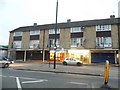
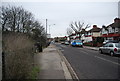
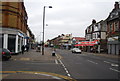
3
Hertford Road
The A1010 seen in the area of Enfield Wash. The road climbs to cross Turkey Brook. On the left is Grove Road West and on the right is Albany Road.
Image: © Martin Addison
Taken: 12 Feb 2011
0.13 miles
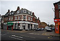
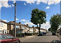
6
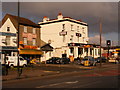
Bar FM
Nineteenth Century pub previously called "The Bell"
Image: © archimandrill
Taken: 19 Feb 2009
0.14 miles