IMAGES TAKEN NEAR TO
Wharf Road, ENFIELD, EN3 4TD
Introduction
This page details the photographs taken nearby to Wharf Road, EN3 4TD by members of the Geograph project.
The Geograph project started in 2005 with the aim of publishing, organising and preserving representative images for every square kilometre of Great Britain, Ireland and the Isle of Man.

There are currently over 7.5m images from over14,400 individuals and you can help contribute to the project by visiting https://www.geograph.org.uk
Image Map
Images are licensed for reuse under creativecommons.org/licenses/by-sa/2.0
Notes
- Clicking on the map will re-center to the selected point.
- The higher the marker number, the further away the image location is from the centre of the postcode.
Image Listing (77 Images Found)
Images are licensed for reuse under creativecommons.org/licenses/by-sa/2.0
Image
Details
Distance
1
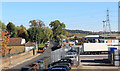
Wharf Road, Ponders End
Heading towards the river Lea. The Valleylink business estate is on the right.
Image: © Des Blenkinsopp
Taken: 9 Oct 2018
0.03 miles
2
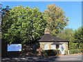
Lodge on Wharf Road
At the end of Wharf Road by the gate into Wright's Flour Mill.
Image: © Des Blenkinsopp
Taken: 9 Oct 2018
0.05 miles
3
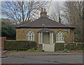
Ponders End : early 19th century 'Gothick' lodge
Located at the entrance of the Wright's flour mill complex.
Image: © Jim Osley
Taken: 14 Jan 2019
0.06 miles
4
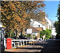
Gate to Wright's Flour Mill
The mill is off to the left. Some houses are in there too by the look of it.
Image: © Des Blenkinsopp
Taken: 9 Oct 2018
0.06 miles
5
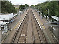
Ponders End railway station, Greater London
Opened in 1840 by the Northern & Eastern Railway on what is today the line from Liverpool Street to Broxbourne.
View north towards Brimsdown and Broxbourne.
Image: © Nigel Thompson
Taken: 19 Sep 2012
0.07 miles
6
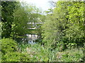
A branch of the River Lee Navigation
The original River Lea flowed 70 miles from Leagrove Marsh near Luton to the River Thames at Bow Creek. The River Lee Act of 1766 provided for the construction of 15 new cuts to straighten the course of the river by eliminating loops which made it difficult to navigate. The Lea passes a little further to the east here, beyond King George's Reservoir. Historically the river is spelled Lea while the navigation is Lee.
This is a short branch of one of those cuts and it is seen here from Wharf Road. As the River Lee Navigation is a navigation rather than a river this is also a navigation although it looks more like a river here.
Image: © Marathon
Taken: 19 Apr 2017
0.08 miles
8
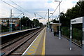
Platform One, Ponders End Railway Station
On the London Liverpool Street line to Broxbourne and Bishop's Stortford.
Image: © Chris Heaton
Taken: 1 Sep 2017
0.09 miles
9
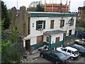
Ponders End: The former Railway Hotel
The railway through Ponders End was constructed in 1840, and this hotel next to the station on South Street followed shortly afterwards in 1841. The 1940s OS map shows the A110 road crossing the railway by a level crossing here, so the trade from the railway and the road must have been reasonable. However the road crossing has gone to be replaced by the Lea Valley Road bridge to the north, and the hotel itself is now closed and in a dilapidated vandalized state. The tablets either side of "The Railway" nameplate read "Watney Combe Reid", a reminder of a brewery that ceased to exist as long ago as 1958 when it merged with another concern to become Watney Mann.
Update October 2018
Reviewing Streetview imagery it is evident that the building had been demolished by November 2009, but the site was then unchanged up to September 2015.
Image: © Nigel Cox
Taken: 26 Apr 2007
0.09 miles
10
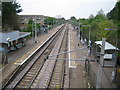
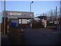
Ponders End railway station
Train services here are operated by One Railway, and there is a weekday half-hourly service to / from London Liverpool Street, scheduled to take between 20 and 25 minutes.
Image: © Nigel Cox
Taken: 26 Apr 2007
0.09 miles