IMAGES TAKEN NEAR TO
Clydesdale, ENFIELD, EN3 4RN
Introduction
This page details the photographs taken nearby to Clydesdale, EN3 4RN by members of the Geograph project.
The Geograph project started in 2005 with the aim of publishing, organising and preserving representative images for every square kilometre of Great Britain, Ireland and the Isle of Man.

There are currently over 7.5m images from over14,400 individuals and you can help contribute to the project by visiting https://www.geograph.org.uk
Image Map
Images are licensed for reuse under creativecommons.org/licenses/by-sa/2.0
Notes
- Clicking on the map will re-center to the selected point.
- The higher the marker number, the further away the image location is from the centre of the postcode.
Image Listing (8 Images Found)
Images are licensed for reuse under creativecommons.org/licenses/by-sa/2.0
Image
Details
Distance
1
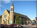
Ponders End: Roman Catholic Church of Mary, Mother of God
Located at 192 Nags Head Road, at its junction with Alexandra Road, the church dates from 1921 but was only consecrated in 1985 http://www.rcdow.org.uk/pondersend/default.asp Local authority paving works in Alexandra Road are in progress outside.
From a cartographical point of view this is a fine indication of the inaccuracies in the OS 1:50,000 scale mapping. In order to match the image to the mapping I have circled the church symbol with a co-ordinate of TQ 35700 96100. However on the five times larger scale OS mapping at 1:10,000 scale the near corner of the church is at TQ 535842 196077, in other words in the next 100 metre grid square both to the east and to the south.
Image: © Nigel Cox
Taken: 1 Feb 2008
0.05 miles
2
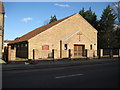
Ponders End: Roman Catholic Church of Mary, Mother of God
This asymmetric building is the Parish Hall of Image and is located on Nags Head Road.
Image: © Nigel Cox
Taken: 1 Feb 2008
0.05 miles
4
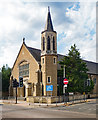
Ponders End: Catholic Church of Mary, Mother of God
Built between 1921 and 1924 to a design by architect Joseph Goldie.
Image: © Jim Osley
Taken: 9 Jul 2018
0.09 miles
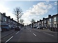
5
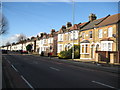
Ponders End: A110 Nags Head Road
Late Victorian terraced houses dominate the scene along this straight stretch of the Nags Head Road.
Image: © Nigel Cox
Taken: 1 Feb 2008
0.13 miles
7
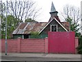
Ponders End: Former Alma Road Mission Room
Or at least the photographer thinks that this is what this derelict building was in 2007. Certainly the Ordnance Survey mapping of 1896, and later editions, show a Mission Room here on this site, although the tin sheet structure seen here must be a later building.
(The co-ordinates are taken from the Where's the Path satellite imagery, not the Ordnance Survey 1:50,000 scale mapping, which is badly distorted here to accommodate the dual carriageway A110 Lea Valley Road, so that the subject and photographer locations appear to be in the middle of the road!)
Update October 2018
Reviewing images on Streetview shows that by August 2008 the tilting tower had gone completely, and by September 2011 the whole building had been demolished, but nothing significant had then changed on the site by April 2018.
Image: © Nigel Cox
Taken: 26 Apr 2007
0.24 miles
8
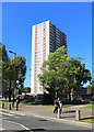
Curlew House, Ponders End
One of four large tower blocks on the Alma Road estate near Ponders End Station. They are colour coded, with different stripes on the side. This is Curlew, the red one.
Kestrel House, nearest the station, has recently been demolished.
Image: © Des Blenkinsopp
Taken: 9 Oct 2018
0.25 miles