IMAGES TAKEN NEAR TO
Florence Drive, ENFIELD, EN2 8DG
Introduction
This page details the photographs taken nearby to Florence Drive, EN2 8DG by members of the Geograph project.
The Geograph project started in 2005 with the aim of publishing, organising and preserving representative images for every square kilometre of Great Britain, Ireland and the Isle of Man.

There are currently over 7.5m images from over14,400 individuals and you can help contribute to the project by visiting https://www.geograph.org.uk
Image Map
Images are licensed for reuse under creativecommons.org/licenses/by-sa/2.0
Notes
- Clicking on the map will re-center to the selected point.
- The higher the marker number, the further away the image location is from the centre of the postcode.
Image Listing (406 Images Found)
Images are licensed for reuse under creativecommons.org/licenses/by-sa/2.0
Image
Details
Distance
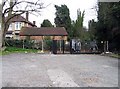
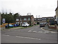
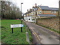
2
Florence Avenue Car Park into Chase Hill, Enfield
Image: © John Salmon
Taken: 10 Mar 2007
0.05 miles
3
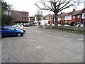
Florence Avenue Car Park towards Windmill Hill, Enfield
Image: © John Salmon
Taken: 10 Mar 2007
0.07 miles
5
West Bank, Enfield
West Bank is a housing development in Enfield, in the outer suburbs of north London.
Image: © Malc McDonald
Taken: 22 Feb 2020
0.09 miles
6
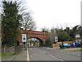
Chase Green Avenue, Enfield
An arch bridge carrying a railway line over Chase Green Avenue in Enfield, in the outer suburbs of north London. The bridge has three arches, with the road passing through the middle one.
The railway is the Hertford loop, a secondary line which leaves the East Coast Main Line at Alexandra Palace, rejoining it at Stevenage. The line is used mainly by suburban trains, but long-distance inter-city trains also use this line on occasions as an alternative to the main line.
Image: © Malc McDonald
Taken: 22 Feb 2020
0.09 miles
7
Chaseside, Enfield
Enfield Chase is an area of undeveloped countryside which now starts about 1km west of here. Presumably it was bigger when Chaseside got its name.
Image: © Des Blenkinsopp
Taken: 11 Jun 2015
0.09 miles
8
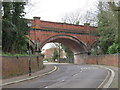
Railway bridge near Enfield
An arch bridge carrying a railway line over Chase Green Avenue in Enfield, in the outer suburbs of north London. The bridge has three arches, with the road passing through the middle one.
The railway is the Hertford loop, a secondary line which leaves the East Coast Main Line at Alexandra Palace, rejoining it at Stevenage. The line is used mainly by suburban trains, but long-distance inter-city trains also use this line on occasions as an alternative to the main line.
Image: © Malc McDonald
Taken: 22 Feb 2020
0.09 miles
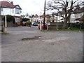
9
Conical Corner, Enfield
Conical Corner is a short residential cul-de-sac in Enfield, in the outer suburbs of north London.
Image: © Malc McDonald
Taken: 22 Feb 2020
0.09 miles
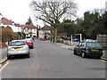
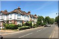
10
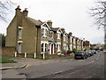
Chase Green Avenue, Enfield
A row of houses on Chase Green Avenue in Enfield, in the outer suburbs of north London.
Image: © Malc McDonald
Taken: 22 Feb 2020
0.09 miles