IMAGES TAKEN NEAR TO
Links Side, ENFIELD, EN2 7RA
Introduction
This page details the photographs taken nearby to Links Side, EN2 7RA by members of the Geograph project.
The Geograph project started in 2005 with the aim of publishing, organising and preserving representative images for every square kilometre of Great Britain, Ireland and the Isle of Man.

There are currently over 7.5m images from over14,400 individuals and you can help contribute to the project by visiting https://www.geograph.org.uk
Image Map (Loading...)


Getting Data...Please wait
Leaflet Map data © OpenStreetMap
Images are licensed for reuse under creativecommons.org/licenses/by-sa/2.0
Notes
- Clicking on the map will re-center to the selected point.
- The higher the marker number, the further away the image location is from the centre of the postcode.
Image Listing (66 Images Found)
Images are licensed for reuse under creativecommons.org/licenses/by-sa/2.0
Image
Details
Distance
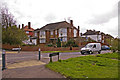
1
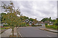
Links Side, Enfield
Looking down Links Side towards the junction with Bincote Road from opposite Linkside Close.
Image: © Christine Matthews
Taken: 7 Oct 2008
0.04 miles
2
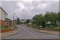
Linkside Close, Enfield
Linkside Close as seen from Links Side.
Image: © Christine Matthews
Taken: 7 Oct 2008
0.05 miles
3
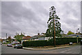
Links Side, Enfield
Corner of Links Side and Linkside Gardens.
Image: © Christine Matthews
Taken: 7 Oct 2008
0.05 miles
4
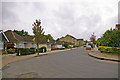
Links Side, Enfield
Looking down Links Side towards the junction with Bincote Road.
Image: © Christine Matthews
Taken: 7 Oct 2008
0.05 miles
5
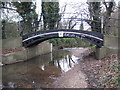
Salmon's Brook: World's End footbridge
Long before the residential developments took place to the north and the adjacent golf course was set out to the south, this was the point at which the route of an old path between Enfield and World's End crossed Salmon's Brook. Old maps show that there was once a ford here, but this rather attractive little footbridge was built to enable a dry passage across the brook.
Salmon's Brook looks quite shallow for a day in December.
Image: © Nigel Cox
Taken: 1 Dec 2010
0.06 miles
6
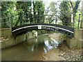
Footbridge over Salmon's Brook
A curious little iron structure, quite substantial for a mere footpath.
Image: © Robin Webster
Taken: 3 Nov 2012
0.06 miles
7
Taunton Drive, Enfield
Taunton Drive is a turning off the west side of Slides Rise.
Image: © Christine Matthews
Taken: 1 Apr 2008
0.07 miles
8
Linkside Gardens, Enfield
Linkside Gardens as seen from Links Side.
Image: © Christine Matthews
Taken: 7 Oct 2008
0.09 miles
9
Slades Rise, Enfield
Slades Rise is a turning off the south side of Slades Hill.
Image: © Christine Matthews
Taken: 1 Apr 2008
0.09 miles
10
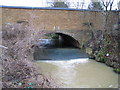
Salmon's Brook: A110 road bridge
Salmon's Brook passes under the A110 road through this bridge and over the weir. At this point the road name changes from Enfield Road on the Oakwood side to the left to Slades Hill on the Enfield side to the right. The brook was carrying far more water and sediment than usual after several rainy days.
Image: © Nigel Cox
Taken: 17 Jan 2008
0.09 miles